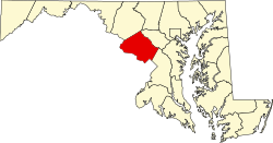
Montgomery County, Maryland

| Vawoitung | |
|---|---|
| US-Bundesstoot: | Maryland |
| Sitz vo da Vawoitung: | Rockville |
| Adress vom Vawoitungssitz: |
Executive Office Building 101 Monroe Street Rockville, MD 20850 |
| Grindung: | 1776 |
| Buidt aus: | Frederick County, Prince George’s County, Charles County |
| Vuawoi: | 001 240 |
| Demographie | |
| Eihwohna: | 971.777 (2010) |
| Dichtn: | 757,4 Eihwohna/km² |
| Eadkund | |
| Flächn gesamt: | 1.313 km² |
| Wossaflächn: | 30 km² |
| Koartn | |
 | |
| Hoamseitn: www.montgomerycountymd.gov | |

Montgomery County[2] is a County im Bundesstoot Maryland in da USA. Des County hod 971.777 Eihwohna. Da Sitz vo da Vawoitung is in Rockville.
Geografie[Werkeln | Am Gwëntext werkeln]
Des County buidt an neadlichn Voaortbereich vo da US-Bundeshaptstod Washington, D.C. und werd im Sidwestn duachn Potomac River begrenzt, der de Grenz zu Virginia buidt.
Des Montgomery County hod a Flächn vo 1313 Quadratkilometa, davo san 30 Quadratkilometa Wossaflächn.
Es grenzt an foignde Countys:
| Frederick County | Howard County | |
| Loudoun County (Virginia) |

|
|
| Fairfax County (Virginia) |
Washington, D.C. | Prince George’s County |
Gmoana[Werkeln | Am Gwëntext werkeln]
Citys[Werkeln | Am Gwëntext werkeln]
Towns[Werkeln | Am Gwëntext werkeln]
- Barnesville
- Brookeville
- Chevy Chase
- Chevy Chase View
- Chevy Chase Village
- Garrett Park
- Glen Echo
- Kensington
- Laytonsville
- Poolesville
- Somerset
- Washington Grove
Villages[Werkeln | Am Gwëntext werkeln]
Special-purpose districts[Werkeln | Am Gwëntext werkeln]
Census-designated places (CDP)[Werkeln | Am Gwëntext werkeln]
- Ashton-Sandy Spring
- Aspen Hill
- Bethesda
- Brookmont
- Burtonsville
- Cabin John
- Calverton1
- Chevy Chase (CDP)
- Clarksburg
- Cloverly
- Colesville
- Damascus
- Darnestown
- Fairland
- Forest Glen
- Germantown
- Glenmont
- Hillandale
- Kemp Mill
- Montgomery Village
- North Bethesda
- North Kensington
- North Potomac
- Olney
- Potomac
- Redland
- Rossmoor
- Silver Spring
- South Kensington
- Travilah
- Wheaton-Glenmont
- White Oak
Unincorporated Communitys[Werkeln | Am Gwëntext werkeln]
1 - teiweis im Prince George’s County
Im Netz[Werkeln | Am Gwëntext werkeln]
- U.S. Census Buero, State & County QuickFacts - Montgomery County
- Maryland State Archives - Montgomery County
- Yahoo Bildersuche - Montgomery County (Seite nicht mehr abrufbar; Suche in Webarchiven)
- www.city-data.com - Montgomery County
Beleg[Werkeln | Am Gwëntext werkeln]
- ↑ Auszug aus dem National Register of Historic Places - Nr. 86003352 Obgruafa am 4. Septemba 2011
- ↑ GNIS-ID: 1712500. Abgerufen am 22. Februar 2011 (englisch).
|
Countys in Maryland
|
