
Datei:Nicaragua relief location map.jpg

Gress dea Voaschau: 704 × 599 Pixel Weitere Auflésungan: 282 × 240 Pixel | 564 × 480 Pixel | 902 × 768 Pixel | 1.203 × 1.024 Pixel | 1.400 × 1.192 Pixel.
Version in hechara Auflesung (1.400 × 1.192 Pixel, Dateigress: 615 KB, MIME-Typ: image/jpeg)
Bschreiwung
| Bschreiwung |
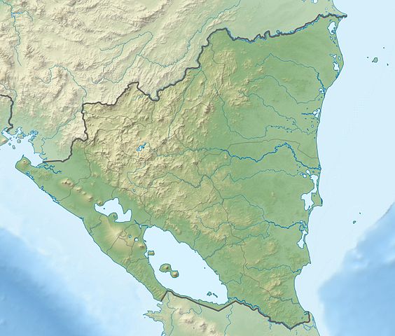
Deutsch: Physische Positionskarte Nicaragua mit Departamentos, Quadratische Plattkarte, N-S-Streckung 100 %. Geographische Begrenzung der Karte:
English: Physical Location map Nicaragua with Departamentos, Equirectangular projection, N/S stretching 100 %. Geographic limits of the map:
|
| Daatum | |
| Quejn | Eigenes Werk, VMAP0, http://maplibrary.org, SRTM3, ETOPO1 |
| Urhéwer | Alexrk2 |
| Aundre Versióner |
Derivative works of this file:
|


|
Diese Karte wurde in der Kartenwerkstatt erstellt oder verbessert. Auch du kannst dort Karten vorschlagen, die zu erstellen, verändern oder übersetzen sind.
|
Lizenz
Diese Datei ist unter der Creative-Commons-Lizenz „Namensnennung – Weitergabe unter gleichen Bedingungen 3.0 nicht portiert“ lizenziert.
- Dieses Werk darf von dir
- vabroatt wern – vafüfötigt, vabroatt und éffantlich zuegénglich gmocht wern.
- neu zusammengestellt werden – abgewandelt und bearbeitet werden
- Zu den folgenden Bedingungen:
- Nåmansnénnung – Du musst angemessene Urheber- und Rechteangaben machen, einen Link zur Lizenz beifügen und angeben, ob Änderungen vorgenommen wurden. Diese Angaben dürfen in jeder angemessenen Art und Weise gemacht werden, allerdings nicht so, dass der Eindruck entsteht, der Lizenzgeber unterstütze gerade dich oder deine Nutzung besonders.
- Weidergob unter gleiche Bedingungan – Wenn du das Material wiedermischst, transformierst oder darauf aufbaust, musst du deine Beiträge unter der gleichen oder einer kompatiblen Lizenz wie das Original verbreiten.
Dateiversiona
Wensd auf an Zeitpunkt klickst, nacha konst a friaane Version lodn.
| Version vom | Vorschaubuidl | Dimensióna | Nutzer | Kommentar | |
|---|---|---|---|---|---|
| aktuell | 23:05, 17. Few. 2010 | | 1.400 × 1.192 (615 KB) | Alexrk2 | == Summary == {{Information |Description= {{de|Physische Positionskarte Nicaragua mit Departamentos, Quadratische Plattkarte, N-S-Streckung 100 %. Geographische Begrenzung der Karte:}} {{en|Physical Location map [[:en:Nicaragua|Nicaragua |
Dateivawendung
Seitn wo de Datei nutzn:
Globale Dateinutzung
D'noochéfóiganden åndern Wikis vawénden dé Datei:
- Vawendung af ar.wikipedia.org
- Vawendung af ast.wikipedia.org
- Vawendung af ba.wikipedia.org
- Vawendung af be-tarask.wikipedia.org
- Vawendung af be.wikipedia.org
- Vawendung af bg.wikipedia.org
- Vawendung af bh.wikipedia.org
- Vawendung af bn.wikipedia.org
- Vawendung af bs.wikipedia.org
- Vawendung af ca.wikipedia.org
- Vawendung af ceb.wikipedia.org
- Vawendung af ce.wikipedia.org
- Vawendung af ckb.wikipedia.org
- Vawendung af cs.wikipedia.org
- Vawendung af da.wikipedia.org
- Vawendung af de.wikipedia.org
Weitere globale Verwendungen dieser Datei anschauen.