
Datei:Dřevíkov, CZ180224-011.jpg

Gress dea Voaschau: 800 × 464 Pixel Weitere Auflésungan: 320 × 186 Pixel | 640 × 371 Pixel | 1.024 × 594 Pixel | 1.280 × 742 Pixel | 2.560 × 1.485 Pixel | 4.623 × 2.681 Pixel.
Version in hechara Auflesung (4.623 × 2.681 Pixel, Dateigress: 4,52 MB, MIME-Typ: image/jpeg)
Bschreiwung
| Bschreiwung |
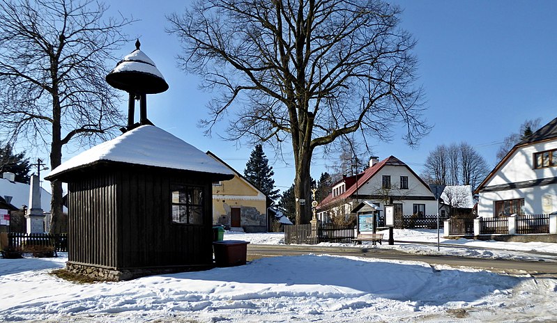
English: "Dřevíkovská" village green, a wooden bell tower, also fulfills the function of a waiting room at the bus stop. In the photo on left the memorial to the victims of the wars 1914-1918 and 1939-1945 and on right the house with a memorial plaque dedicated to teacher and writer, to Czech patriot "František Hrnčíř" (1860–1928). On a tree (linden) above the road is a signpost of the tourist route of the Czech Tourists Club, also a small sacred structure, the so-called God's torture and the information board on the Homeland trail the Region of Chrudimka River (point 10 - "Dřevíkovská" village green). "Dřevíkov" is settlement locality of the type of small hamlet and the name of the cadastral area with an area of 226.58 ha with a range of approximately 534 to 579 meters above sea level in the landscape area of the Iron Mountains, within the administrative is part municipality of Vysočina in the district of Chrudim belonging to the Pardubice Region in the territory of the Czech Republic. Photo location: Czechia, Pardubice Region, municipality Vysočina, hamlet of "Dřevíkov", "Stružinecká" knoll hill.
Čeština: Dřevíkovská náves s dřevěnou zvoničkou (malá stavba slouží současně jako čekárna autobusové zastávky). Vlevo pomník obětem válek 1914–1918 a 1939–1945, vpravo dům s pamětní deskou věnovanou učiteli a spisovateli Františku Hrnčířovi (1860–1928), místnímu rodákovi a českému vlastenci. Na stromu (lípa) nad silnicí je rozcestník zeleně značené turistické trasy Klubu českých turistů (úsek Veselý Kopec – Dřevíkov – Svobodné Hamry), také malá sakrální stavba, tzv. Boží muka a informační tabule vlastivědné stezky Krajem Chrudimky (stanoviště č. 10 s názvem Dřevíkovská náves). Dřevíkov je sídelní lokalita typu vesnice a název katastrálního území o rozloze 226,58 ha s rozsahem poloh přibližně 534 až 579 m n. m. v krajinné oblasti Železných hor, v rámci administrativně správním část obce Vysočina v okrese Chrudim náležejícím do Pardubického kraje na území České republiky. Foto lokace: Česko, Pardubický kraj, obec Vysočina, vesnice Dřevíkov, Stružinecká pahorkatina (190°). |
| Daatum | |
| Quejn | Eigenes Werk |
| Urhéwer | Josef Kreuz (PEPan) |
| Kameraposition | | Dieses und weitere Bilder auf OpenStreetMap |
|---|
Externí odkazy:
- Mapy.cz, turistická mapa (letecký pohled) – Dřevíkov viz
- Obec Vysočina – webové stránky viz
Lizenz
Diese Datei ist lizenziert unter der Creative-Commons-Lizenz „Namensnennung – Weitergabe unter gleichen Bedingungen 4.0 international“.
- Dieses Werk darf von dir
- vabroatt wern – vafüfötigt, vabroatt und éffantlich zuegénglich gmocht wern.
- neu zusammengestellt werden – abgewandelt und bearbeitet werden
- Zu den folgenden Bedingungen:
- Nåmansnénnung – Du musst angemessene Urheber- und Rechteangaben machen, einen Link zur Lizenz beifügen und angeben, ob Änderungen vorgenommen wurden. Diese Angaben dürfen in jeder angemessenen Art und Weise gemacht werden, allerdings nicht so, dass der Eindruck entsteht, der Lizenzgeber unterstütze gerade dich oder deine Nutzung besonders.
- Weidergob unter gleiche Bedingungan – Wenn du das Material wiedermischst, transformierst oder darauf aufbaust, musst du deine Beiträge unter der gleichen oder einer kompatiblen Lizenz wie das Original verbreiten.
Dateiversiona
Wensd auf an Zeitpunkt klickst, nacha konst a friaane Version lodn.
| Version vom | Vorschaubuidl | Dimensióna | Nutzer | Kommentar | |
|---|---|---|---|---|---|
| aktuell | 17:14, 24. Few. 2018 | | 4.623 × 2.681 (4,52 MB) | PEPan | User created page with UploadWizard |
Dateivawendung
Seitn wo de Datei nutzn:
Globale Dateinutzung
D'noochéfóiganden åndern Wikis vawénden dé Datei:
- Vawendung af cs.wikipedia.org
- Vawendung af fr.wikipedia.org