
Datei:Equatorial Guinea, administrative divisions - de - colored 2020.svg

Version in hechara Auflesung (SVG-Datei, Basisgress: 1.091 × 1.042 Pixl, Dateigress: 194 KB)
Bschreiwung


.svg)


_(Paris_zoom).svg)
.svg)
,_administrative_divisions_-_de_-_colored_(multizoom).svg)
_-_colored.svg)
.svg)
,_administrative_divisions_-_Nmbrs_(multizoom).svg)
,_administrative_divisions_-_de_-_colored.svg)
_-_de_-_colored.svg)

.svg)

.svg)
Lizenz
Weiternutzung dieser Karte mit:

Rechtsgültig ist alleine der Lizenzvertrag in seinem Wortlaut. Für eine kostenlose Weiternutzung empfehle ich besonders die Beachtung folgender Lizenzbedingungen:
1. Fügen Sie meinen Namen wie oben angegeben bei: NordNordWest,
2. eine Kopie dieser Lizenz oder deren vollständige Internetadresse bei: https://creativecommons.org/licenses/by-sa/3.0/de/legalcode
3. und im Falle einer Abwandlung einen Hinweis darauf, dass es sich um eine Abwandlung handelt.
Im Falle eines Verstoßes gegen die Lizenzbedingungen erlöschen die eingeräumten Nutzungsrechte automatisch.
Wenn Sie Fragen haben oder andere Nutzungsbedingungen wünschen, kontaktieren Sie mich bitte über nnwest oder hinterlassen mir eine Nachricht auf meiner Diskussionsseite (unangemeldet möglich). Ich freue mich über Mitteilungen, wo meine Karten verwendet werden, oder Belegexemplare. ![]() t-online.de
t-online.de
- Dieses Werk darf von dir
- vabroatt wern – vafüfötigt, vabroatt und éffantlich zuegénglich gmocht wern.
- neu zusammengestellt werden – abgewandelt und bearbeitet werden
- Zu den folgenden Bedingungen:
- Nåmansnénnung – Du musst angemessene Urheber- und Rechteangaben machen, einen Link zur Lizenz beifügen und angeben, ob Änderungen vorgenommen wurden. Diese Angaben dürfen in jeder angemessenen Art und Weise gemacht werden, allerdings nicht so, dass der Eindruck entsteht, der Lizenzgeber unterstütze gerade dich oder deine Nutzung besonders.
- Weidergob unter gleiche Bedingungan – Wenn du das Material wiedermischst, transformierst oder darauf aufbaust, musst du deine Beiträge unter der gleichen oder einer kompatiblen Lizenz wie das Original verbreiten.

Dateiversiona
Wensd auf an Zeitpunkt klickst, nacha konst a friaane Version lodn.
| Version vom | Vorschaubuidl | Dimensióna | Nutzer | Kommentar | |
|---|---|---|---|---|---|
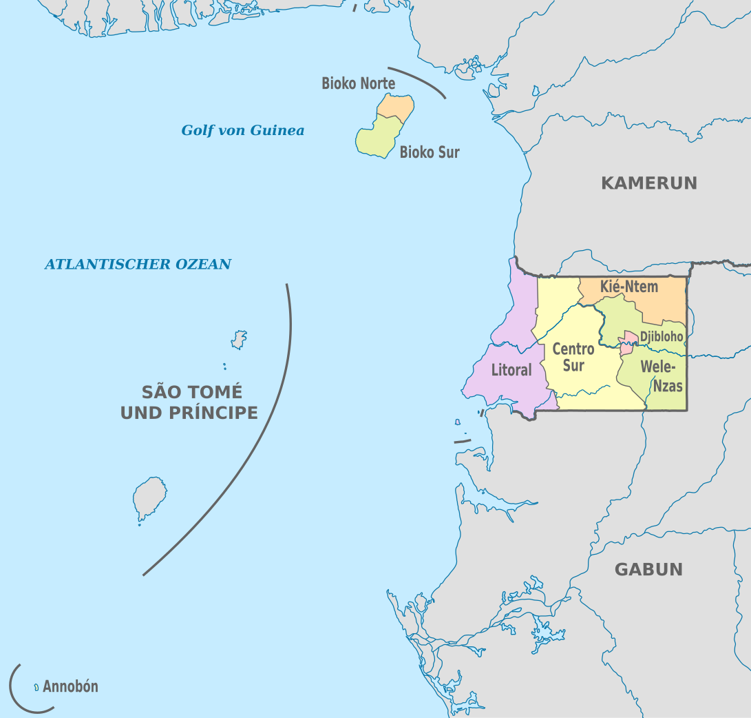
| aktuell | 21:53, 25. Nóv. 2020 | | 1.091 × 1.042 (194 KB) | NordNordWest | == {{int:filedesc}} == {{Information |Description={{de|Karte der politischen Gliederung von Äquatorialguinea, Stand 2020}} {{en|Map of the administrative divisions of Equatorial Guinee}} |Source={{own}} |date=2020-11-25 |author={{U|NordNordWest}} |permission= |other_versions={{SVG labeled maps of administrative divisions (location map scheme)}} }} == {{int:license-header}} == {{User:NordNordWest/LicenceMap}} [[Category:SVG labeled maps of administrative divisions of Equatorial Guinea (locat... |
Dateivawendung
Seitn wo de Datei nutzn:
Globale Dateinutzung
D'noochéfóiganden åndern Wikis vawénden dé Datei:
- Vawendung af ab.wikipedia.org
- Vawendung af ca.wikipedia.org
- Vawendung af cs.wikipedia.org
- Vawendung af de.wikipedia.org
- Vawendung af en.wikipedia.org
- Vawendung af eo.wikipedia.org
- Vawendung af fi.wikipedia.org
- Vawendung af frr.wikipedia.org
- Vawendung af gl.wikipedia.org
- Vawendung af id.wikipedia.org
- Vawendung af is.wikipedia.org
- Vawendung af it.wikipedia.org
- Vawendung af ja.wikipedia.org
- Vawendung af lv.wikipedia.org
- Vawendung af nl.wikipedia.org
- Vawendung af ru.wikipedia.org
- Vawendung af tr.wikipedia.org
- Vawendung af zh.wikipedia.org