
Datei:Gilarivermap.png
Es gibt koa hehare Aflesung.
Gilarivermap.png (499 × 500 Pixel, Dateigress: 382 KB, MIME-Typ: image/png)
| Bschreiwung |
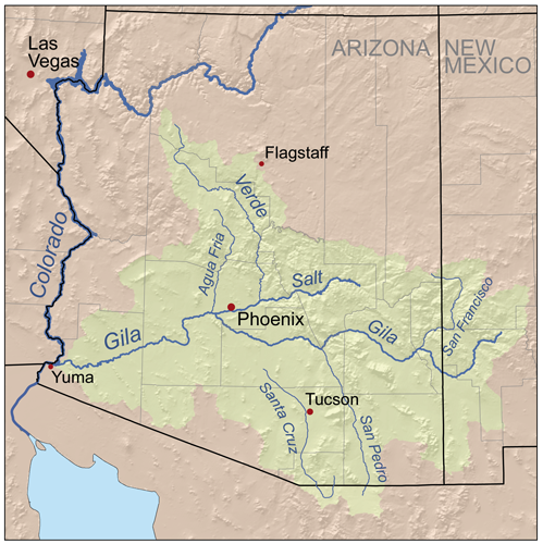
English: Map of the Gila River watershed-drainage basin — located in New Mexico and Arizona.
|
| Daatum | |
| Quejn | Self-made, based on USGS data. |
| Urhéwer | Kmusser |
Diese Datei ist unter der Creative-Commons-Lizenz „Namensnennung – Weitergabe unter gleichen Bedingungen 2.5 generisch“ (US-amerikanisch) lizenziert.
- Dieses Werk darf von dir
- vabroatt wern – vafüfötigt, vabroatt und éffantlich zuegénglich gmocht wern.
- neu zusammengestellt werden – abgewandelt und bearbeitet werden
- Zu den folgenden Bedingungen:
- Nåmansnénnung – Du musst angemessene Urheber- und Rechteangaben machen, einen Link zur Lizenz beifügen und angeben, ob Änderungen vorgenommen wurden. Diese Angaben dürfen in jeder angemessenen Art und Weise gemacht werden, allerdings nicht so, dass der Eindruck entsteht, der Lizenzgeber unterstütze gerade dich oder deine Nutzung besonders.
- Weidergob unter gleiche Bedingungan – Wenn du das Material wiedermischst, transformierst oder darauf aufbaust, musst du deine Beiträge unter der gleichen oder einer kompatiblen Lizenz wie das Original verbreiten.
Dateiversiona
Wensd auf an Zeitpunkt klickst, nacha konst a friaane Version lodn.
| Version vom | Vorschaubuidl | Dimensióna | Nutzer | Kommentar | |
|---|---|---|---|---|---|
| aktuell | 20:48, 13. Sep. 2007 | | 499 × 500 (382 KB) | Kmusser | {{Information |Description=Map of the Gila River watershed. |Source=Self-made, based on USGS data. |Date=September 13, 2007 |Author= Kmusser }} {{self|cc-by-sa-2.5}} [[Category:Maps of rivers of the Unite |
Dateivawendung
Seitn wo de Datei nutzn:
Globale Dateinutzung
D'noochéfóiganden åndern Wikis vawénden dé Datei:
- Vawendung af af.wikipedia.org
- Vawendung af ar.wikipedia.org
- Vawendung af arz.wikipedia.org
- Vawendung af bg.wikipedia.org
- Vawendung af ca.wikipedia.org
- Vawendung af ceb.wikipedia.org
- Vawendung af cs.wikipedia.org
- Vawendung af cy.wikipedia.org
- Vawendung af de.wikipedia.org
- Vawendung af en.wikipedia.org
- San Francisco River (Gila River tributary)
- Gila River
- Verde River
- Juan Bautista de Anza National Historic Trail
- User:Kmusser/Images
- List of tributaries of the Gila River
- Agua Fria River
- Category:Regions of Arizona
- San Pedro River (Arizona)
- Salt River Valley
- Centennial Wash (Maricopa County)
- East Verde River
- Category:Gila River
- List of longest rivers of the United States (by main stem)
- Vawendung af es.wikipedia.org
- Vawendung af et.wikipedia.org
- Vawendung af fa.wikipedia.org
- Vawendung af fi.wikipedia.org
- Vawendung af fr.wikipedia.org
- Vawendung af he.wikipedia.org
Weitere globale Verwendungen dieser Datei anschauen.