
Datei:Iceberg A22A, South Atlantic Ocean.jpg

Gress dea Voaschau: 800 × 530 Pixel Weitere Auflésungan: 320 × 212 Pixel | 640 × 424 Pixel | 1.024 × 678 Pixel | 1.280 × 848 Pixel | 2.345 × 1.553 Pixel.
Version in hechara Auflesung (2.345 × 1.553 Pixel, Dateigress: 793 KB, MIME-Typ: image/jpeg)
Bschreiwung
| Bschreiwung |
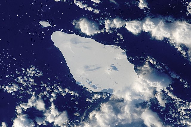
English: This astronaut photograph illustrates the remains of a giant iceberg—designated A22A— that broke off Antarctica in 2002. The iceberg was photographed at a location of 49.9 degrees south latitude, 23.8 degrees west longitude, which is about a third of the distance from South America towards Cape Town, South Africa. A22A is one of the largest icebergs to drift as far north as 50 degrees south latitude, bringing it beneath the daylight path of the International Space Station (ISS). Crew members aboard the ISS were able to locate the ice mass and photograph it, despite the great masses of clouds that often accompany winter storms in the Southern Ocean. The crew’s viewing angle was oblique (not looking straight down) from a point to the west of the berg, and the time of day was early afternoon, as shown by the orientation of the cloud shadows. Dimensions of A22A in early June were 49.9 by 23.4 kilometres, giving it an area of 622 square kilometres, or seven times the area of Manhattan Island.
|
||||||||||||||||||||||||||||||||||||||||||||||||||
| Daatum | |||||||||||||||||||||||||||||||||||||||||||||||||||
| Quejn | {{URL|example.com|optional display text}} | ||||||||||||||||||||||||||||||||||||||||||||||||||
| Urhéwer | Image provided by the ISS Crew Earth Observations experiment and the Image Science & Analysis Laboratory, NASA - Johnson Space Center. | ||||||||||||||||||||||||||||||||||||||||||||||||||
| Objektposition | | Dieses und weitere Bilder auf OpenStreetMap |
|---|
Diese Mediendatei wurde vom Johnson Space Center der US-amerikanischen National Aeronautics and Space Administration (NASA) unter der Datei-ID ISS015-E-10125 kategorisiert. Diese Markierung zeigt nicht den Urheberrechtsstatus des zugehörigen Werks an. Es ist in jedem Falle zusätzlich eine normale Lizenzvorlage erforderlich. Siehe Commons:Lizenzen für weitere Informationen. Sprachen:
|
Lizenz
| De Datai is gmoafrai (public domain), wais vo da NASA erstöid worn is. In da NASA-Urheewerrechtsrichtlinie steet, dass as „NASA-Materiaal ned durch Urheewerrecht gschytzt is, wånns ned ånders ågeem is“. (NASA-Urheewerrechtsrichtlinie-Saiten oder JPL Image Use Policy). | ||
 |
Warnung:
|
Dateiversiona
Wensd auf an Zeitpunkt klickst, nacha konst a friaane Version lodn.
| Version vom | Vorschaubuidl | Dimensióna | Nutzer | Kommentar | |
|---|---|---|---|---|---|
| aktuell | 17:25, 22. Mer. 2013 | | 2.345 × 1.553 (793 KB) | Julian Herzog | Higher resolution and quality |
| 21:54, 5. Jul. 2009 |  | 1.000 × 1.000 (376 KB) | Originalwana | {{Information |Description={{en|1=This astronaut photograph illustrates the remains of a giant iceberg—designated A22A— that broke off Antarctica in 2002. The iceberg was photographed at a location of 49.9 degrees south latitude, 23.8 degrees west lon |
Dateivawendung
Seitn wo de Datei nutzn:
Globale Dateinutzung
D'noochéfóiganden åndern Wikis vawénden dé Datei:
- Vawendung af ar.wikipedia.org
- Vawendung af az.wikipedia.org
- Vawendung af bn.wikipedia.org
- Vawendung af cy.wikipedia.org
- Vawendung af en.wikipedia.org
- Vawendung af eo.wikipedia.org
- Vawendung af it.wikipedia.org
- Vawendung af it.wikibooks.org
- Vawendung af it.wikiversity.org
- Vawendung af la.wikipedia.org
- Vawendung af mk.wikipedia.org
- Vawendung af pt.wikipedia.org
- Vawendung af sl.wikipedia.org
- Vawendung af ta.wikipedia.org
- Vawendung af ta.wiktionary.org
- Vawendung af th.wikipedia.org