
Datei:Shetland UK relief location map.jpg

Gress dea Voaschau: 315 × 599 Pixel Weitere Auflésungan: 126 × 240 Pixel | 252 × 480 Pixel | 404 × 768 Pixel | 538 × 1.024 Pixel | 1.999 × 3.802 Pixel.
Version in hechara Auflesung (1.999 × 3.802 Pixel, Dateigress: 505 KB, MIME-Typ: image/jpeg)
| Bschreiwung |
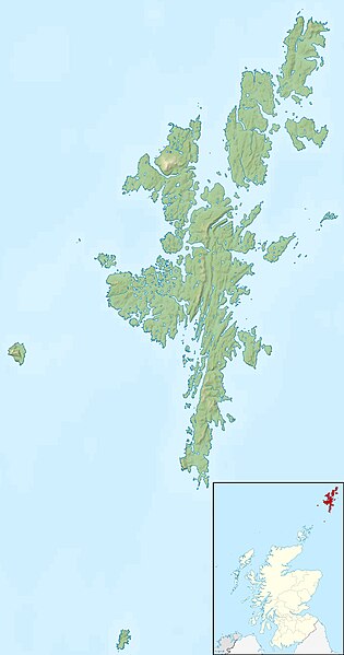
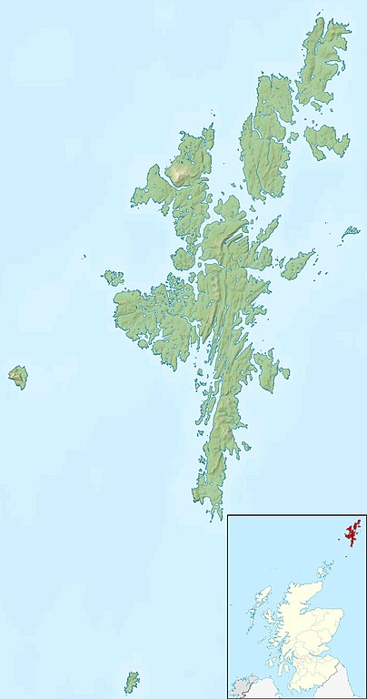
Relief map of the Shetland Islands, UK. Equirectangular map projection on WGS 84 datum, with N/S stretched 200% Geographic limits:
|
| Daatum | |
| Quejn |
|
| Urhéwer | Nilfanion, created using Ordnance Survey data |
| Gnémigung (Weidernutzung voh derer Daatei) |
Diese Datei ist unter der Creative-Commons-Lizenz „Namensnennung – Weitergabe unter gleichen Bedingungen 3.0 nicht portiert“ lizenziert. Namensnennung: Contains Ordnance Survey data © Crown copyright and database right
|
| Aundre Versióner | File:Shetland UK blank map.svg - Blank map |
Dateiversiona
Wensd auf an Zeitpunkt klickst, nacha konst a friaane Version lodn.
| Version vom | Vorschaubuidl | Dimensióna | Nutzer | Kommentar | |
|---|---|---|---|---|---|
| aktuell | 14:29, 30. Nóv. 2011 | | 1.999 × 3.802 (505 KB) | Nilfanion | {{Information |Description=Relief map of the Shetland Islands, UK. Equirectangular map projection on WGS 84 datum, with N/S stretched 200% Geographic limits: *West: 2.15W *East: 0.70W *North: 60.88N *South: 59.50N |Source=[[w:Ordn |
Dateivawendung
Seitn wo de Datei nutzn:
Globale Dateinutzung
D'noochéfóiganden åndern Wikis vawénden dé Datei:
- Vawendung af ar.wikipedia.org
- Vawendung af ast.wikipedia.org
- Vawendung af bg.wikipedia.org
- Vawendung af ca.wikipedia.org
- Vawendung af ceb.wikipedia.org
- Vawendung af da.wikipedia.org
- Vawendung af de.wikipedia.org
- Vawendung af de.wikivoyage.org
- Vawendung af en.wikipedia.org
Weitere globale Verwendungen dieser Datei anschauen.