
Datei:Sweden Norrbotten location map.svg

Größe der PNG-Vorschau dieser SVG-Datei: 511 × 599 Pixel. Weitere Auflésungan: 205 × 240 Pixel | 409 × 480 Pixel | 655 × 768 Pixel | 873 × 1.024 Pixel | 1.747 × 2.048 Pixel | 853 × 1.000 Pixel.
Version in hechara Auflesung (SVG-Datei, Basisgress: 853 × 1.000 Pixl, Dateigress: 1,02 MB)
Bschreiwung
| Bschreiwung |
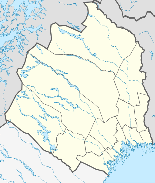
English: Location map of Norrbotten County in Sweden
Equirectangular projection, N/S stretching 257 %. Geographic limits of the map:
Deutsch: Positionskarte von Norrbottens län in Schweden
Quadratische Plattkarte, N-S-Streckung 257 %. Geographische Begrenzung der Karte:
|
| Daatum | |
| Quejn | Eigenes Werk |
| Urhéwer | Erik Frohne |
Lizenz

|
Es ist erlaubt, die Datei unter den Bedingungen der GNU-Lizenz für freie Dokumentation, Version 1.2 oder einer späteren Version, veröffentlicht von der Free Software Foundation, zu kopieren, zu verbreiten und/oder zu modifizieren; es gibt keine unveränderlichen Abschnitte, keinen vorderen und keinen hinteren Umschlagtext.
Der vollständige Text der Lizenz ist im Kapitel GNU-Lizenz für freie Dokumentation verfügbar. |
Diese Datei ist unter der Creative-Commons-Lizenz „Namensnennung – Weitergabe unter gleichen Bedingungen 3.0 nicht portiert“ lizenziert.
- Dieses Werk darf von dir
- vabroatt wern – vafüfötigt, vabroatt und éffantlich zuegénglich gmocht wern.
- neu zusammengestellt werden – abgewandelt und bearbeitet werden
- Zu den folgenden Bedingungen:
- Nåmansnénnung – Du musst angemessene Urheber- und Rechteangaben machen, einen Link zur Lizenz beifügen und angeben, ob Änderungen vorgenommen wurden. Diese Angaben dürfen in jeder angemessenen Art und Weise gemacht werden, allerdings nicht so, dass der Eindruck entsteht, der Lizenzgeber unterstütze gerade dich oder deine Nutzung besonders.
- Weidergob unter gleiche Bedingungan – Wenn du das Material wiedermischst, transformierst oder darauf aufbaust, musst du deine Beiträge unter der gleichen oder einer kompatiblen Lizenz wie das Original verbreiten.
Dateiversiona
Wensd auf an Zeitpunkt klickst, nacha konst a friaane Version lodn.
| Version vom | Vorschaubuidl | Dimensióna | Nutzer | Kommentar | |
|---|---|---|---|---|---|
| aktuell | 02:28, 23. Apr. 2017 | | 853 × 1.000 (1,02 MB) | Silverkey | Complete redrawing (the previous version was horribly inaccurate) |
| 17:32, 2. Mer. 2009 |  | 853 × 1.000 (572 KB) | Erik Frohne | {{Information |Description={{en|1=Location map of Norrbotten county in Sweden Equirectangular projection, N/S stretching 257 %. Geographic limits of the map: * N: 69.10° N * S: 64.90° N * W: 15.10° E * E: 24.30° E}} {{de|1=Positionskarte von Norrbot |
Dateivawendung
Seitn wo de Datei nutzn:
Globale Dateinutzung
D'noochéfóiganden åndern Wikis vawénden dé Datei:
- Vawendung af ar.wikipedia.org
- Vawendung af bg.wikipedia.org
- Vawendung af ceb.wikipedia.org
- Vawendung af cs.wikipedia.org
- Vawendung af da.wikipedia.org
- Abisko
- Luleå
- Boden (Sverige)
- Abisko Nationalpark
- Gällivare
- Hortlax
- Malmberget
- Haparanda
- Piteå
- Flyulykken på Kebnekaise 2012
- Skabelon:Kortpositioner Sverige Norrbotten
- Björlings gletsjer
- Arjeplog
- Sikfors (Piteå kommun)
- Mellanström
- Slagnäs
- Sjulsmark (Piteå kommun)
- Strömsund (Luleå kommun)
- Råneå
- Nyborg (Sverige)
- Rolfs
- Påläng
- Glommersträsk
- Vawendung af de.wikipedia.org
Weitere globale Verwendungen dieser Datei anschauen.