
Datei:West Midlands counties 2009 map.svg

Größe der PNG-Vorschau dieser SVG-Datei: 533 × 600 Pixel. Weitere Auflésungan: 213 × 240 Pixel | 427 × 480 Pixel | 683 × 768 Pixel | 910 × 1.024 Pixel | 1.821 × 2.048 Pixel | 1.161 × 1.306 Pixel.
Version in hechara Auflesung (SVG-Datei, Basisgress: 1.161 × 1.306 Pixl, Dateigress: 1,38 MB)
Bschreiwung
| Bschreiwung |
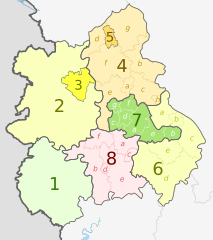
English: Map of the West Midlands region of England, showing its counties and administrative districts. The county colours are the same as those in File:English metropolitan and non-metropolitan counties 2009.svg.
Equirectangular map projection on WGS 84 datum, with N/S stretched 165% Geographic limits:
|
| Daatum | (UTC) |
| Quejn |
Diese Datei wurde von diesen Werken abgeleitet: |
| Urhéwer |
|
| Aundre Versióner |
 |


| Map | Ceremonial county | Shire county / unitary | Districts |
|---|---|---|---|
 |
1. Herefordshire U.A. | ||
| Shropshire | 2. Shropshire U.A. | ||
| 3. Telford and Wrekin U.A. | |||
| Staffordshire | 4. Staffordshire † | a) Cannock Chase, b) East Staffordshire, c) Lichfield, d) Newcastle-under-Lyme, e) South Staffordshire, f) Stafford, g) Staffordshire Moorlands, h) Tamworth | |
| 5. Stoke-on-Trent U.A. | |||
| 6. Warwickshire † | a) North Warwickshire, b) Nuneaton and Bedworth, c) Rugby, d) Stratford-on-Avon, e) Warwick | ||
| 7. West Midlands * | a) Birmingham, b) Coventry, c) Dudley, d) Sandwell, e) Solihull, f) Walsall, g) Wolverhampton | ||
| 8. Worcestershire † | a) Bromsgrove, b) Malvern Hills, c) Redditch, d) Worcester, e) Wychavon, f) Wyre Forest | ||
Key: †shire county | *metropolitan county
Lizenz
Diese Datei ist unter der Creative-Commons-Lizenz „Namensnennung – Weitergabe unter gleichen Bedingungen 3.0 nicht portiert“ lizenziert.
Namensnennung: Dr Greg and Nilfanion. Contains Ordnance Survey data © Crown copyright and database right 2011
- Dieses Werk darf von dir
- vabroatt wern – vafüfötigt, vabroatt und éffantlich zuegénglich gmocht wern.
- neu zusammengestellt werden – abgewandelt und bearbeitet werden
- Zu den folgenden Bedingungen:
- Nåmansnénnung – Du musst angemessene Urheber- und Rechteangaben machen, einen Link zur Lizenz beifügen und angeben, ob Änderungen vorgenommen wurden. Diese Angaben dürfen in jeder angemessenen Art und Weise gemacht werden, allerdings nicht so, dass der Eindruck entsteht, der Lizenzgeber unterstütze gerade dich oder deine Nutzung besonders.
- Weidergob unter gleiche Bedingungan – Wenn du das Material wiedermischst, transformierst oder darauf aufbaust, musst du deine Beiträge unter der gleichen oder einer kompatiblen Lizenz wie das Original verbreiten.
Ursprüngliches Datei-Logbuch
This image is a derivative work of the following images:
- File:West_Midlands_districts_2011_map.svg licensed with Cc-by-sa-3.0, GFDL
- 2011-05-01T19:06:46Z Nilfanion 1161x1306 (1392730 Bytes) == Summary == {{Information |Description=Map of the [[w:West Midlands|West Midlands]] region showing the administrative districts. Equirectangular map projection on WGS 84 datum, with N/S stretched 165% Geographic limits: *
- File:English_ceremonial_counties_2010.svg licensed with Cc-by-sa-3.0, GFDL
- 2010-11-23T16:39:55Z Nilfanion 1108x1345 (308868 Bytes) thicker lines
- 2010-11-23T16:20:19Z Nilfanion 1108x1345 (301520 Bytes) tweaks
- 2010-10-26T20:34:20Z Nilfanion 817x990 (1391832 Bytes) {{Information |Description=Map showing the [[w:ceremonial counties of England]] including the City of London, in 2010. Equirectangular map projection on WGS 84 datum, with N/S stretched 170% Geographic limits: *West: 6.75W
Hochgeladen mit derivativeFX
Dateiversiona
Wensd auf an Zeitpunkt klickst, nacha konst a friaane Version lodn.
| Version vom | Vorschaubuidl | Dimensióna | Nutzer | Kommentar | |
|---|---|---|---|---|---|
| aktuell | 22:01, 5. Mai 2012 | | 1.161 × 1.306 (1,38 MB) | Dr Greg | lighten black boundary line |
| 23:19, 2. Mai 2012 |  | 1.161 × 1.306 (1,38 MB) | Dr Greg | == {{int:filedesc}} == {{Information |Description={{en|Map of the West Midlands region of England, showing its counties and administrative districts. The county colours are the same as those in [[:File:English metropolitan ... |
Dateivawendung
Seitn wo de Datei nutzn:
Globale Dateinutzung
D'noochéfóiganden åndern Wikis vawénden dé Datei:
- Vawendung af ar.wikipedia.org
- Vawendung af de.wikipedia.org
- Vawendung af en.wikipedia.org
- Vawendung af fa.wikipedia.org
- Vawendung af frr.wikipedia.org
- Vawendung af fr.wikipedia.org
- Vawendung af hr.wikipedia.org
- Vawendung af hu.wikipedia.org
- Vawendung af mr.wikipedia.org
- Vawendung af pl.wikipedia.org
- Vawendung af pnb.wikipedia.org
- Vawendung af pt.wikipedia.org
- Vawendung af th.wikipedia.org
- Vawendung af tr.wikipedia.org
- Vawendung af ur.wikipedia.org
- Vawendung af vec.wikipedia.org
- Vawendung af vi.wikipedia.org
- Vawendung af vls.wikipedia.org
- Vawendung af zh-yue.wikipedia.org