
Datei:Falkland Islands map.svg

Größe der PNG-Vorschau dieser SVG-Datei: 769 × 600 Pixel. Weitere Auflésungan: 308 × 240 Pixel | 616 × 480 Pixel | 985 × 768 Pixel | 1.280 × 998 Pixel | 2.560 × 1.996 Pixel | 1.090 × 850 Pixel.
Version in hechara Auflesung (SVG-Datei, Basisgress: 1.090 × 850 Pixl, Dateigress: 583 KB)

|
Diese Datei wurde durch File:Falkland Islands topographic map-en.svg ersetzt. Es wird empfohlen, die andere Datei zu verwenden. Bitte beachte, dass das Löschen ersetzter Bilder einer Löschdiskussion bedarf. Grund: „More precise map; created from NASA's digital elevation model“
|

|
Bschreiwung
| Bschreiwung |
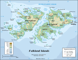
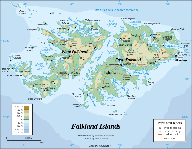
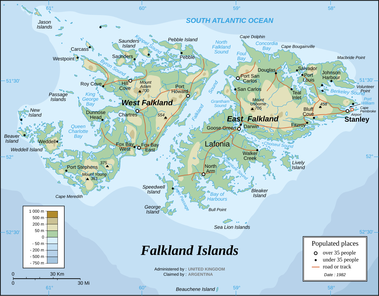
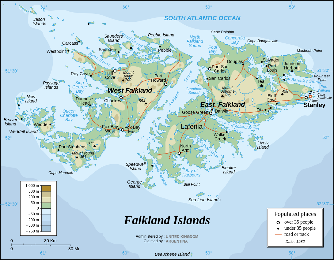
English: The Falkland Islands are an archipelago in the South Atlantic Ocean, located 300 miles off the coast of Argentina. They consist of two main islands, East Falkland and West Falkland, together with about 700 smaller islands. Stanley, on East Falkland, is the capital and largest city. The islands are a self-governing Overseas Territory of the United Kingdom, but have been the subject of a claim to sovereignty by Argentina since the British invasion of 1833.
Français : Carte en anglais des îles Malouines |
| Daatum | |
| Quejn |
Own work Background and elevation reference maps : Microsoft Encarta atlas (1999 edition) and UK government map 1982 demographic data : CIA map available on the site of the University of Texas at Austin |
| Urhéwer | Eric Gaba (Sting) |
| Aundre Versióner | in French: Iles Malouines carte.svg |
| SVG‑Erstellung |
Français :
- Sujet : Carte en anglais des îles Malouines ;
- Sources : Création personnelle
- Fond de carte et relief basés sur : atlas Encarta de Microsoft (édition 1999) et carte du gouvernement britannique ;
- Données démographiques de 1982 : carte de la CIA disponible sur la site de l'Université du Texas à Austin ;
- Auteur : Eric Gaba (fr:Sting) ;
- Date : Septembre 2006.
- Autre version : francophone : Image:Iles_Malouines_carte.svg
Lizenz
Diese Datei ist unter der Creative-Commons-Lizenz „Namensnennung – Weitergabe unter gleichen Bedingungen 2.5 generisch“ (US-amerikanisch) lizenziert.
- Dieses Werk darf von dir
- vabroatt wern – vafüfötigt, vabroatt und éffantlich zuegénglich gmocht wern.
- neu zusammengestellt werden – abgewandelt und bearbeitet werden
- Zu den folgenden Bedingungen:
- Nåmansnénnung – Du musst angemessene Urheber- und Rechteangaben machen, einen Link zur Lizenz beifügen und angeben, ob Änderungen vorgenommen wurden. Diese Angaben dürfen in jeder angemessenen Art und Weise gemacht werden, allerdings nicht so, dass der Eindruck entsteht, der Lizenzgeber unterstütze gerade dich oder deine Nutzung besonders.
- Weidergob unter gleiche Bedingungan – Wenn du das Material wiedermischst, transformierst oder darauf aufbaust, musst du deine Beiträge unter der gleichen oder einer kompatiblen Lizenz wie das Original verbreiten.
Dateiversiona
Wensd auf an Zeitpunkt klickst, nacha konst a friaane Version lodn.
| Version vom | Vorschaubuidl | Dimensióna | Nutzer | Kommentar | |
|---|---|---|---|---|---|
| aktuell | 22:06, 31. Mer. 2007 | | 1.090 × 850 (583 KB) | Sting | Some text corrections |
| 04:58, 28. Sep. 2006 |  | 1.090 × 850 (586 KB) | Sting | Cosmetic correction | |
| 04:48, 28. Sep. 2006 |  | 1.090 × 850 (586 KB) | Sting | {{Information |Description=Map of the Falkland Islands |Source=1982 demographic data : [http://www.lib.utexas.edu/maps/americas/falkland_islands.gif CIA map] available on the site of the [http://www.lib.utexas.edu/maps/americas.html#F University of Texas |
Dateivawendung
Koa Seitn nutzt de Datei.
Globale Dateinutzung
D'noochéfóiganden åndern Wikis vawénden dé Datei:
- Vawendung af azb.wikipedia.org
- Vawendung af de.wikipedia.org
- Vawendung af en.wikipedia.org
- Vawendung af es.wikinews.org
- Vawendung af gd.wikipedia.org
- Vawendung af he.wikipedia.org
- Vawendung af it.wikipedia.org
- Vawendung af ja.wikipedia.org
- Vawendung af lt.wikipedia.org
- Vawendung af no.wikipedia.org
- Vawendung af ro.wikipedia.org
- Vawendung af sr.wikipedia.org
- Vawendung af wuu.wikipedia.org