
Datei:Luxembourg administrative subdivisions coloured.gif
Gress dea Voaschau: 444 × 599 Pixel Weitere Auflésungan: 178 × 240 Pixel | 600 × 809 Pixel.
Version in hechara Auflesung (600 × 809 Pixel, Dateigress: 30 KB, MIME-Typ: image/gif)
Bschreiwung
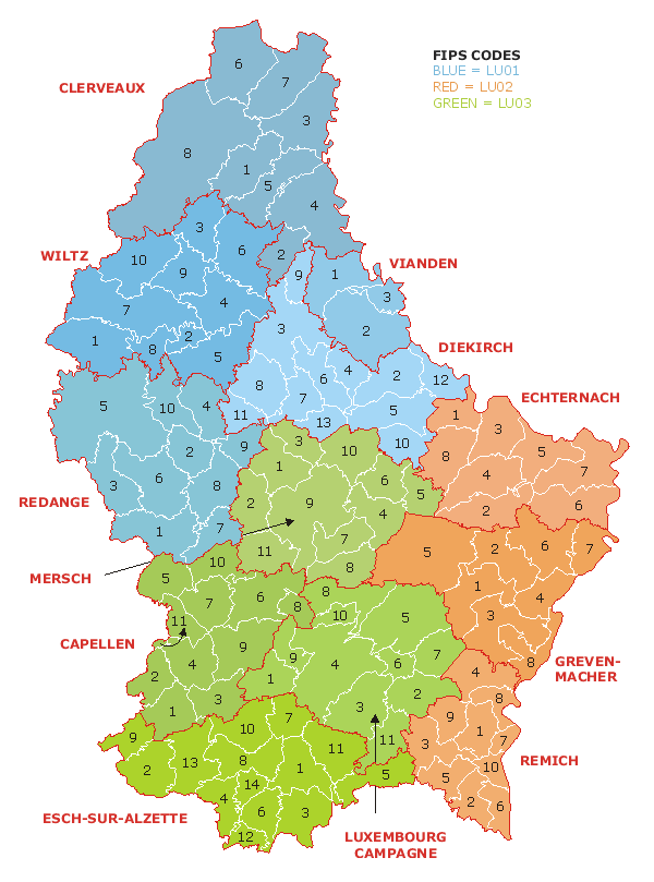
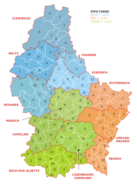
| Bschreiwung | Map of the administrative divisions of Luxembourg. Districts, cantons, and communes are marked and numbered according to FIPS code. |
| Daatum | |
| Quejn | Own work based on w:Image:Luxembourg.geohive.gif, which previously had all rights released by its original author and publisher, GeoHive. Updated for the commune mergers of 2006-01-01. |
| Urhéwer | User:Bastin8 |
| Gnémigung (Weidernutzung voh derer Daatei) |
Released into public domain. See licence below. |
Lizenz
| Ich, der Urheberrechtsinhaber dieses Werkes, veröffentliche es als gemeinfrei. Dies gilt weltweit. In manchen Staaten könnte dies rechtlich nicht möglich sein. Sofern dies der Fall ist: Ich gewähre jedem das bedingungslose Recht, dieses Werk für jedweden Zweck zu nutzen, es sei denn, Bedingungen sind gesetzlich erforderlich. |
Dateiversiona
Wensd auf an Zeitpunkt klickst, nacha konst a friaane Version lodn.
| Version vom | Vorschaubuidl | Dimensióna | Nutzer | Kommentar | |
|---|---|---|---|---|---|
| aktuell | 02:19, 21. Jul. 2006 | | 600 × 809 (30 KB) | Bastin8 | {{Information |Description=Map of the administrative divisions of Luxembourg. Districts, cantons, and communes are marked and numbered according to FIPS code. |Source=Own work based on w:Image:Luxembourg.geohive.gif, which previously had all rights r |
Dateivawendung
Seitn wo de Datei nutzn:
Globale Dateinutzung
D'noochéfóiganden åndern Wikis vawénden dé Datei:
- Vawendung af an.wikipedia.org
- Vawendung af ast.wikipedia.org
- Vawendung af es.wikipedia.org
- Vawendung af eu.wikipedia.org
- Vawendung af fur.wikipedia.org
- Vawendung af gag.wikipedia.org
- Vawendung af id.wikipedia.org
- Vawendung af it.wikipedia.org
- Vawendung af kk.wikipedia.org
- Vawendung af ko.wikipedia.org
- Vawendung af lt.wikipedia.org
- Vawendung af mk.wikipedia.org
- Vawendung af nl.wikipedia.org
- Vawendung af pt.wikipedia.org
- Vawendung af ro.wikipedia.org
- Vawendung af ru.wikipedia.org
- Vawendung af sco.wikipedia.org
- Vawendung af sq.wikipedia.org
- Vawendung af tr.wikipedia.org
- Vawendung af uz.wikipedia.org
- Vawendung af zh.wikipedia.org