
Datei:Red Centre Way Map.png

Gress dea Voaschau: 800 × 521 Pixel Weitere Auflésungan: 320 × 208 Pixel | 640 × 416 Pixel | 979 × 637 Pixel.
Version in hechara Auflesung (979 × 637 Pixel, Dateigress: 135 KB, MIME-Typ: image/png)
Bschreiwung
| Bschreiwung |
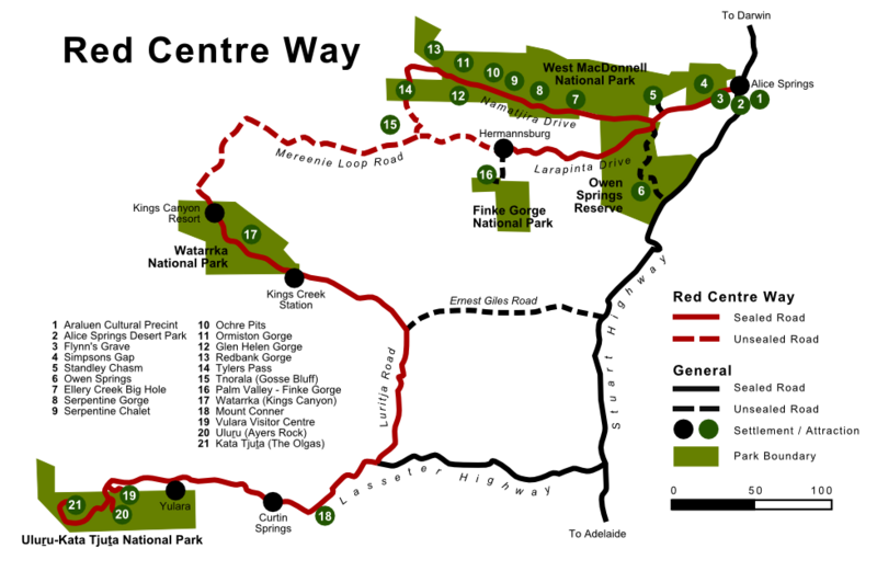
English: Map of the Red Centre Way in the Australian Northern Territory, including surrounding attractions, settlements and major non-RCW roads. Based on the map sign at the intersection of Stuart and Lasseter Highways.
This map was created in SVG format using Inkscape and the original files exist, but the Wikimedia software doesn't render it correct so I uploaded the PNG only.
Deutsch: Karte des Red Centre Ways im australischen Northern Territory. Enthalten sind zudem die umgebenden Attraktionen und Siedlungen als auch große eigentlich nicht zum RCW gehörende Straßen. Basierend auf dem Kartenschild das an der Kreuzung von Stuart und Lasseter Highway aufgestellt ist.
Diese Karte wurde mit Inkscape im SVG-Format erstellt und die Originaldateien existieren, allerdings rendert die Wikimedia-Software sie nicht korrekt weshalb ich nur die PNG-Version hochgeladen habe. |
| Daatum | |
| Quejn | Eigenes Werk |
| Urhéwer | Christallkeks |
Lizenz
Diese Datei ist unter der Creative-Commons-Lizenz „Namensnennung – Weitergabe unter gleichen Bedingungen 3.0 nicht portiert“ lizenziert.
- Dieses Werk darf von dir
- vabroatt wern – vafüfötigt, vabroatt und éffantlich zuegénglich gmocht wern.
- neu zusammengestellt werden – abgewandelt und bearbeitet werden
- Zu den folgenden Bedingungen:
- Nåmansnénnung – Du musst angemessene Urheber- und Rechteangaben machen, einen Link zur Lizenz beifügen und angeben, ob Änderungen vorgenommen wurden. Diese Angaben dürfen in jeder angemessenen Art und Weise gemacht werden, allerdings nicht so, dass der Eindruck entsteht, der Lizenzgeber unterstütze gerade dich oder deine Nutzung besonders.
- Weidergob unter gleiche Bedingungan – Wenn du das Material wiedermischst, transformierst oder darauf aufbaust, musst du deine Beiträge unter der gleichen oder einer kompatiblen Lizenz wie das Original verbreiten.
Dateiversiona
Wensd auf an Zeitpunkt klickst, nacha konst a friaane Version lodn.
| Version vom | Vorschaubuidl | Dimensióna | Nutzer | Kommentar | |
|---|---|---|---|---|---|
| aktuell | 16:35, 8. Sep. 2012 | | 979 × 637 (135 KB) | Christallkeks | {{Information |Description ={{en|1=Map of the Red Centre Way in the Australian Northern Territory, including surrounding attractions, settlements and major non-RCW roads. Based on the map sign at the intersection of Stuart and Lasseter Highways. Thi... |
Dateivawendung
Seitn wo de Datei nutzn:
Globale Dateinutzung
D'noochéfóiganden åndern Wikis vawénden dé Datei:
- Vawendung af de.wikipedia.org
- Vawendung af en.wikipedia.org
- Vawendung af en.wikivoyage.org
- Vawendung af it.wikivoyage.org
- Vawendung af www.wikidata.org