Beziak Boudry
| District de Boudry | |
|---|---|
| Basisdatn | |
| Stoot: | Schweiz |
| Kanton: | Neuenbuag (NE) |
| Haptoat: | Boudry |
| Fläch: | 105.46 km² |
| Eihwohna: | 40'701 (31. Dezémber 2017) |
| Dichtn: | 386 Eihw. pro km² |
| Koartn | |
 | |
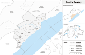
Da District de Boudry woa bis m 31. Dezemba 2017 a Beziak van Kanton Neuenbuag in da Schweiz.
Zan Beziak hom foingnde Gmoana(Stond: 1. Jenna 2016) oghead:
| Woppm | Nam vo da Gmoa | Einhwohna (31. Dezemba 2018) |
Fläch in km²[1] |
Eihw. pro km² |
|---|---|---|---|---|
| Bevaix | 3784 | 10,70 | 354 | |
| Boudry | 6124 | 16,76 | 365 | |
| Corcelles-Cormondrèche | 4740 | 4,85 | 977 | |
| Cortaillod | 4774 | 3,68 | 1297 | |
| Fresens | 252 | 1,59 | 158 | |
| Gorgier | 2021 | 13,99 | 144 | |
| Milvignes | 9008 | 8,78 | 1026 | |
| Montalchez | 240 | 6,40 | 38 | |
| Peseux | 5825 | 3,39 | 1718 | |
| Rochefort | 1266 | 25,85 | 49 | |
| Saint-Aubin-Sauges | 2399 | 7,70 | 312 | |
| Vaumarcus | 268 | 1,77 | 151 | |
| Total (12) | 40'701 | 105,46 | 386 | |
Veaendarunga im Gmoabstond[Werkeln | Am Gwëntext werkeln]
- 1870: Fusion Areuse und Boudry → Boudry
- 1875: Fusion Vaumarcus und Vernéaz → Vaumarcus-Vernéaz
- 1888: Fusion Saint-Aubin und Sauges → Saint-Aubin-Sauges
- 1966: Namasendarung vo Vaumarcus-Vernéaz → Vaumarcus
- 2013: Fusion Auvernier, Bôle und Colombier → Milvignes
- 2016: Fusion Brot-Dessous, Rochefort → Rochefort


