
Datei:C74112s5 Ant.Map Martin Peninsula.jpg

Gress dea Voaschau: 581 × 599 Pixel Weitere Auflésungan: 233 × 240 Pixel | 465 × 480 Pixel | 745 × 768 Pixel | 993 × 1.024 Pixel | 1.985 × 2.048 Pixel | 3.621 × 3.735 Pixel.
Version in hechara Auflesung (3.621 × 3.735 Pixel, Dateigress: 1,52 MB, MIME-Typ: image/jpeg)
Bschreiwung
| Bschreiwung |
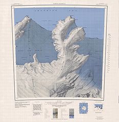
English: 1:250,000-scale topographic reconnaissance map of the Martin Peninsula area from 112°30'-117°W to 73°45'-75°S in Antarctica, including the eastern parts of the Getz Ice Shelf and the western parts of Dotson Ice Shelf. Mapped, edited and published by the U.S. Geological Survey in cooperation with the National Science Foundation. |
|||
| Daatum | ||||
| Quejn | http://usarc.usgs.gov/drg_dload.shtml | |||
| Urhéwer | United States Geological Survey | |||
| Gnémigung (Weidernutzung voh derer Daatei) |
|
Dateiversiona
Wensd auf an Zeitpunkt klickst, nacha konst a friaane Version lodn.
| Version vom | Vorschaubuidl | Dimensióna | Nutzer | Kommentar | |
|---|---|---|---|---|---|
| aktuell | 08:31, 4. Apr. 2005 | | 3.621 × 3.735 (1,52 MB) | Achim Raschka | Map of Antarctica by the United States Antarctic Ressource Center of the US Geological Society. {{PD-US}} Copyrights and Trademarks USGS-authored or produced data and information are in the public domain. While the content of most USGS web pages is in th |
Dateivawendung
Seitn wo de Datei nutzn:
Globale Dateinutzung
D'noochéfóiganden åndern Wikis vawénden dé Datei:
- Vawendung af ceb.wikipedia.org
- Vawendung af de.wikipedia.org
- Martin-Halbinsel
- Kap Felt
- Kap Herlacher
- Binder Rocks
- Siglin Rocks
- Schneider Rock
- Klimov Bluff
- Jenkins Heights
- McClinton-Gletscher
- Spaulding-Halbinsel
- Coyer Point
- Jacobsen Head
- Slichter Foreland
- Dorchuck-Gletscher
- Klinger Ridge
- Ellis Ridge
- Keys-Gletscher
- Furman Bluffs
- Philbin Inlet
- Murray Foreland
- Hadley Point
- Maumee-Piedmont-Gletscher
- Rydelek-Eisfälle
- Smythe Shoulder
- Singer-Gletscher
- Tucker Point
- Nowicki Foreland
- Vawendung af en.wikipedia.org
- Vawendung af fr.wikipedia.org
- Vawendung af he.wikipedia.org
- Vawendung af hi.wikipedia.org
- Vawendung af it.wikipedia.org
Weitere globale Verwendungen dieser Datei anschauen.