
Datei:Canary Islands de.png

Gress dea Voaschau: 800 × 418 Pixel Weitere Auflésungan: 320 × 167 Pixel | 640 × 334 Pixel | 1.024 × 535 Pixel | 1.280 × 668 Pixel | 2.000 × 1.044 Pixel.
Version in hechara Auflesung (2.000 × 1.044 Pixel, Dateigress: 976 KB, MIME-Typ: image/png)
Bschreiwung
| Bschreiwung |
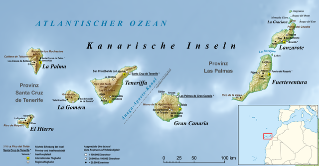
Deutsch: Karte der Kanarischen Inseln, inklusive Teneriffa, Fuerteventura, Gran Canaria, Lanzarote, La Palma, La Gomera, El Hierro, Lobos, La Graciosa, Alegranza und Pico del Teide
English: Map of Canary Islands |
| Daatum | |
| Quejn |
own work, used:
|
| Urhéwer | Lencer |

|
Diese Karte wurde in der Kartenwerkstatt erstellt oder verbessert. Auch du kannst dort Karten vorschlagen, die zu erstellen, verändern oder übersetzen sind.
|
Lizenz
Diese Datei ist unter der Creative-Commons-Lizenz „Namensnennung – Weitergabe unter gleichen Bedingungen 3.0 nicht portiert“ lizenziert.
- Dieses Werk darf von dir
- vabroatt wern – vafüfötigt, vabroatt und éffantlich zuegénglich gmocht wern.
- neu zusammengestellt werden – abgewandelt und bearbeitet werden
- Zu den folgenden Bedingungen:
- Nåmansnénnung – Du musst angemessene Urheber- und Rechteangaben machen, einen Link zur Lizenz beifügen und angeben, ob Änderungen vorgenommen wurden. Diese Angaben dürfen in jeder angemessenen Art und Weise gemacht werden, allerdings nicht so, dass der Eindruck entsteht, der Lizenzgeber unterstütze gerade dich oder deine Nutzung besonders.
- Weidergob unter gleiche Bedingungan – Wenn du das Material wiedermischst, transformierst oder darauf aufbaust, musst du deine Beiträge unter der gleichen oder einer kompatiblen Lizenz wie das Original verbreiten.
Dateiversiona
Wensd auf an Zeitpunkt klickst, nacha konst a friaane Version lodn.
| Version vom | Vorschaubuidl | Dimensióna | Nutzer | Kommentar | |
|---|---|---|---|---|---|
| aktuell | 12:55, 2. Few. 2021 | | 2.000 × 1.044 (976 KB) | Lencer | added Peñas del Chache, 671 m |
| 13:06, 30. Jén. 2021 |  | 2.000 × 1.044 (975 KB) | Lencer | + Flughäfen, + Legende, + Fixes, + Anaga-Agethe-Kanal | |
| 18:58, 29. Jén. 2021 |  | 2.000 × 1.044 (949 KB) | Lencer | == {{int:filedesc}} == {{Information |Description= {{de|Karte der Kanarischen Inseln, inklusive Teneriffa, Fuerteventura, Gran Canaria, Lanzarote, La Palma, La Gomera, El Hierro, Lobos, La Graciosa, Alegranza und Pico del Teide}} {{en|Map of [[:en:Canary Islands|C... |
Dateivawendung
Seitn wo de Datei nutzn:
Globale Dateinutzung
D'noochéfóiganden åndern Wikis vawénden dé Datei:
- Vawendung af de.wikipedia.org
- Vawendung af frr.wikipedia.org
- Vawendung af ro.wikipedia.org