
Datei:Corse region relief location map.jpg

Gress dea Voaschau: 304 × 600 Pixel Weitere Auflésungan: 121 × 240 Pixel | 243 × 480 Pixel | 824 × 1.625 Pixel.
Version in hechara Auflesung (824 × 1.625 Pixel, Dateigress: 324 KB, MIME-Typ: image/jpeg)
Bschreiwung
| Kameraposition | | Dieses und weitere Bilder auf OpenStreetMap |
|---|
| Bschreiwung |
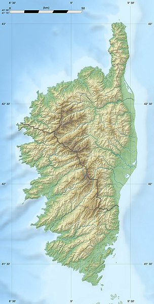
English: Blank physical map of the region of Corsica, France, for geo-location purpose, with distinct boundaries for departments and arrondissements as they are since January 2010.
The former version of the map shows the boundaries as they were until December 2009. Français : Carte physique vierge de la région Corse, France, destinée à la géolocalisation, avec limite distincte des départements et arrondissements tels que depuis janvier 2010. L'ancienne version de la carte montre le découpage administratif tel qu'il était jusqu'en décembre 2009. Scales: 1:520,000 (precision: 130 m) for the topography; 1:7,420,000 (precision: 1,855 m) for the bathymetry
Geographic limits of the map:
|
||
| Daatum | 2008-08, modified 02-2010 | ||
| Quejn |
Eigenes Werk
|
||
| Urhéwer | Eric Gaba (Sting - fr:Sting) | ||
| Gnémigung (Weidernutzung voh derer Daatei) |
|
||
| Aundre Versióner |
|

Lizenz
Diese Datei ist unter der Creative-Commons-Lizenz „Namensnennung – Weitergabe unter gleichen Bedingungen 3.0 nicht portiert“ lizenziert.
- Dieses Werk darf von dir
- vabroatt wern – vafüfötigt, vabroatt und éffantlich zuegénglich gmocht wern.
- neu zusammengestellt werden – abgewandelt und bearbeitet werden
- Zu den folgenden Bedingungen:
- Nåmansnénnung – Du musst angemessene Urheber- und Rechteangaben machen, einen Link zur Lizenz beifügen und angeben, ob Änderungen vorgenommen wurden. Diese Angaben dürfen in jeder angemessenen Art und Weise gemacht werden, allerdings nicht so, dass der Eindruck entsteht, der Lizenzgeber unterstütze gerade dich oder deine Nutzung besonders.
- Weidergob unter gleiche Bedingungan – Wenn du das Material wiedermischst, transformierst oder darauf aufbaust, musst du deine Beiträge unter der gleichen oder einer kompatiblen Lizenz wie das Original verbreiten.

|
Es ist erlaubt, die Datei unter den Bedingungen der GNU-Lizenz für freie Dokumentation, Version 1.2 oder einer späteren Version, veröffentlicht von der Free Software Foundation, zu kopieren, zu verbreiten und/oder zu modifizieren; es gibt keine unveränderlichen Abschnitte, keinen vorderen und keinen hinteren Umschlagtext.
Der vollständige Text der Lizenz ist im Kapitel GNU-Lizenz für freie Dokumentation verfügbar. |
Dateiversiona
Wensd auf an Zeitpunkt klickst, nacha konst a friaane Version lodn.
| Version vom | Vorschaubuidl | Dimensióna | Nutzer | Kommentar | |
|---|---|---|---|---|---|
| aktuell | 15:50, 18. Jul. 2010 | | 824 × 1.625 (324 KB) | Sting | Color profile |
| 20:33, 22. Few. 2010 |  | 824 × 1.625 (317 KB) | Sting | Updated arrondissments boundaries of Haute-Corse | |
| 21:50, 14. Aug. 2008 |  | 824 × 1.625 (315 KB) | Sting | == Summary == {{Location|42|12|00|N|09|03|00|E|scale:2000000}} <br/> {{Information |Description={{en|Blank physical map of the region of Corsica, France, for geo-location purpose, with distinct boundaries for departments and arrondissement |
Dateivawendung
Seitn wo de Datei nutzn:
Globale Dateinutzung
D'noochéfóiganden åndern Wikis vawénden dé Datei:
- Vawendung af als.wikipedia.org
- Vawendung af ang.wikipedia.org
- Vawendung af ar.wikipedia.org
- Vawendung af ast.wikipedia.org
- Vawendung af bg.wikipedia.org
- Vawendung af bn.wikipedia.org
- Vawendung af bs.wikipedia.org
- Vawendung af ca.wikipedia.org
- Vawendung af ceb.wikipedia.org
- Vawendung af cs.wikipedia.org
- Vawendung af de.wikipedia.org
- Vawendung af de.wikivoyage.org
- Vawendung af dsb.wikipedia.org
- Vawendung af el.wikipedia.org
- Vawendung af en.wikipedia.org
Weitere globale Verwendungen dieser Datei anschauen.