
Datei:Iran relief location map.jpg

Gress dea Voaschau: 672 × 600 Pixel Weitere Auflésungan: 269 × 240 Pixel | 538 × 480 Pixel | 861 × 768 Pixel | 1.200 × 1.071 Pixel.
Version in hechara Auflesung (1.200 × 1.071 Pixel, Dateigress: 941 KB, MIME-Typ: image/jpeg)
Bschreiwung
| Bschreiwung |
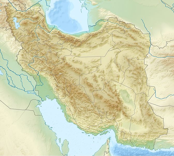
English: Location map of Iran.
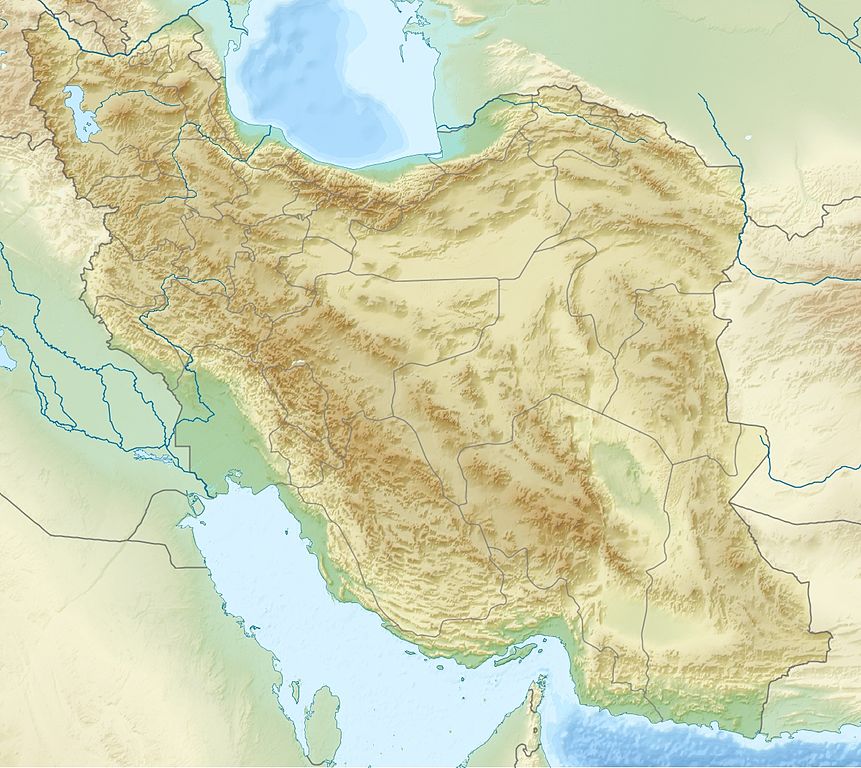
Equirectangular projection. Strechted by 118.0%. Geographic limits of the map: * N: 40.0° N * S: 24.5° N * W: 43.5° E * E: 64.0° EMade with Natural Earth. Free vector and raster map data @ naturalearthdata.com. Deutsch: Topografische Karte des Iranischen Hochlandes mit der Verbindung zu Kleinasien im Westen und zum Hindukusch und Himalaya im Osten.
English: Topographic map of the Iranian plateau in Central Asia, connecting to Anatolia in the west and Hindu Kush and Himalaya in the east.
Español: Mapa topográfico de la Meseta iraní. Mapa topográfico de la meseta iraní que enlaza Anatolia en el oeste con el Hindu Kush y el Himalaya en el Este.
Euskara: Irango goi-ordokiaren mapa topografikoa, Anatolia mendebaldean eta Hindu Kush eta Himalaia ekialdean.
فارسی: فلات ایران سرزمین مرتفعی است در همسایگی مناطق کم ارتفاع غرب، شمال و جنوب آسیا.
Français : Carte du plateau iranien en Asie, lié à l'Anatolie à l'ouest, et à l'Hindu Kush et à l'Himalaya à l'est.
한국어: 이란 고원의 서쪽으로는 아나톨리아로 연결되고, 동쪽으로는 힌두쿠시 산맥와 히말라야 산맥과 연결된다.
Nederlands: Kaart van het Hoogland van Iran in Azië, dat zich uitstrekt van Anatolië in het westen tot aan de Hindoekoesj en de Himalaya in het oosten.
Norsk bokmål: Topografisk kart over det iranske høylandet, som grenser til Anatolia i vest og Hindu Kush og Himalaya i øst.
پنجابی: سطح مرتفع ایران دا نقشہ ، لہندے چ اناطولیا تے چڑھدے چ کوہ ہندوکش تے ہمالیہ نال جڑئیا.
Português: Mapa topográfico do planalto iraniano ligando a Anatólia a oeste e o Hindu Kush e os Himalaias a este.
Русский: Иранское нагорье располагается между Аравийским полуостровом на западе и севером Индийского субконтинента на востоке.
Türkçe: Batıda Anadolu'ya doğuda ise Hindukuş ve Himalaya dağlarına bağlanan İran platosunun topografik haritası.
اردو: سطع مرتفع ایران کا نقشہ، مغرب میں اناطولیہ اور مشرق میں ہندوکش اور ہمالیہ سے منسلک.
Tiếng Việt: Bản đồ địa hình với sơn nguyên Iran nối Anatolia ở phía tây với Hindu Kush và Himalaya ở phía đông.
中文:伊朗高原地形圖,連接安納托利亞西部,東與喜馬拉雅山相鄰. |
| Daatum | |
| Quejn | Eigenes Werk |
| Urhéwer | Uwe Dedering |
| Aundre Versióner |
|


Lizenz
Diese Datei ist unter der Creative-Commons-Lizenz „Namensnennung – Weitergabe unter gleichen Bedingungen 3.0 nicht portiert“ lizenziert.
- Dieses Werk darf von dir
- vabroatt wern – vafüfötigt, vabroatt und éffantlich zuegénglich gmocht wern.
- neu zusammengestellt werden – abgewandelt und bearbeitet werden
- Zu den folgenden Bedingungen:
- Nåmansnénnung – Du musst angemessene Urheber- und Rechteangaben machen, einen Link zur Lizenz beifügen und angeben, ob Änderungen vorgenommen wurden. Diese Angaben dürfen in jeder angemessenen Art und Weise gemacht werden, allerdings nicht so, dass der Eindruck entsteht, der Lizenzgeber unterstütze gerade dich oder deine Nutzung besonders.
- Weidergob unter gleiche Bedingungan – Wenn du das Material wiedermischst, transformierst oder darauf aufbaust, musst du deine Beiträge unter der gleichen oder einer kompatiblen Lizenz wie das Original verbreiten.

|
Es ist erlaubt, die Datei unter den Bedingungen der GNU-Lizenz für freie Dokumentation, Version 1.2 oder einer späteren Version, veröffentlicht von der Free Software Foundation, zu kopieren, zu verbreiten und/oder zu modifizieren; es gibt keine unveränderlichen Abschnitte, keinen vorderen und keinen hinteren Umschlagtext.
Der vollständige Text der Lizenz ist im Kapitel GNU-Lizenz für freie Dokumentation verfügbar. |
Dateiversiona
Wensd auf an Zeitpunkt klickst, nacha konst a friaane Version lodn.
| Version vom | Vorschaubuidl | Dimensióna | Nutzer | Kommentar | |
|---|---|---|---|---|---|
| aktuell | 22:09, 11. Jul. 2010 | | 1.200 × 1.071 (941 KB) | Uwe Dedering | 31. province Alborz |
| 17:51, 23. Apr. 2010 |  | 1.200 × 1.071 (941 KB) | Uwe Dedering | {{Information |Description={{en|1=Location map of Iran. Equirectangular projection. Strechted by 118.0%. Geographic limits of the map: * N: 40.0° N * S: 24.5° N * W: 43.5° E * E: 64.0° E Made with Natural Earth. Free vector and raster map data @ |
Dateivawendung
Seitn wo de Datei nutzn:
Globale Dateinutzung
D'noochéfóiganden åndern Wikis vawénden dé Datei:
- Vawendung af als.wikipedia.org
- Vawendung af ar.wikipedia.org
- Vawendung af ary.wikipedia.org
- Vawendung af ast.wikipedia.org
- Vawendung af av.wikipedia.org
- Vawendung af azb.wikipedia.org
- Vawendung af az.wikipedia.org
Weitere globale Verwendungen dieser Datei anschauen.