
Datei:Uganda Protectorate British administration.png

Gress dea Voaschau: 528 × 600 Pixel Weitere Auflésungan: 211 × 240 Pixel | 422 × 480 Pixel | 661 × 751 Pixel.
Version in hechara Auflesung (661 × 751 Pixel, Dateigress: 18 KB, MIME-Typ: image/png)
Bschreiwung
| Bschreiwung |
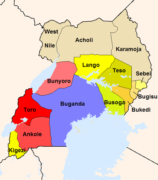
English: The map shows the British administration units in the Uganda Protectorate (borders of 1926).
The reddish areas and the blue Buganda are areas, where traditional kingdoms were maintained. In the yellowish areas Baganda-type administration was introduced. The khaki areas had no sole traditional rule before. |
| Quejn |
Eigenes Werk
|
| Urhéwer | Slomox |
Lizenz
| Ich, der Urheberrechtsinhaber dieses Werkes, veröffentliche es als gemeinfrei. Dies gilt weltweit. In manchen Staaten könnte dies rechtlich nicht möglich sein. Sofern dies der Fall ist: Ich gewähre jedem das bedingungslose Recht, dieses Werk für jedweden Zweck zu nutzen, es sei denn, Bedingungen sind gesetzlich erforderlich. |
Dateiversiona
Wensd auf an Zeitpunkt klickst, nacha konst a friaane Version lodn.
| Version vom | Vorschaubuidl | Dimensióna | Nutzer | Kommentar | |
|---|---|---|---|---|---|
| aktuell | 02:44, 22. Few. 2008 | | 661 × 751 (18 KB) | Mahahahaneapneap | pngcrushed |
| 22:34, 18. Sep. 2005 |  | 661 × 751 (34 KB) | Slomox | little correction | |
| 21:36, 18. Sep. 2005 |  | 661 × 751 (33 KB) | Slomox | The map shows the British administration units in the Uganda Protectorate (borders of 1926). The map is based on data given in ''A History of East Africa'' by Odhiambo, Ouso and Williams. The reddish areas and the blue Buganda are areas, where traditiona |
Dateivawendung
Seitn wo de Datei nutzn:
Globale Dateinutzung
D'noochéfóiganden åndern Wikis vawénden dé Datei:
- Vawendung af als.wikipedia.org
- Vawendung af de.wikipedia.org
- Vawendung af en.wikipedia.org
- Vawendung af es.wikipedia.org
- Vawendung af fr.wikipedia.org
- Vawendung af io.wikipedia.org
- Vawendung af it.wikipedia.org
- Vawendung af ja.wikipedia.org
- Vawendung af lt.wikipedia.org
- Vawendung af no.wikipedia.org
- Vawendung af pt.wikipedia.org
- Vawendung af ru.wikipedia.org
- Vawendung af uk.wikipedia.org
- Vawendung af vec.wikipedia.org