Ørsta
Erscheinungsbild
| Woppn | Koartn | |
|---|---|---|

|
||
| Basisdatn | ||
| Gmoanummara: | 1520 (auf Statistik Norwegen) | |
| Provinz (fylke): | Møre og Romsdal | |
| Vawoitungssiez: | Ørsta | |
| Koordinatn: | 62° 12′ N, 6° 8′ O | |
| Fläch: | 803 km² | |
| Eihwohna: |
10.783 (30. Jun. 2017)[1] | |
| Dichtn: | 13 Einwohner je km² | |
| Sproch: | Nynorsk | |
| Postleitzahl: | 6150 | |
| Hoamseitn: | ||
| Politik | ||
| Buagamoasta: | Gudny Fagerhol (Ap) (2007) | |
| Log in da Provinz Møre og Romsdal | ||

| ||
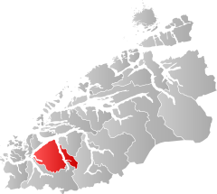
Ørsta is a Ort und a Kommune im norwegischn Fylke Møre og Romsdal. As Vawoitungszentrum vo da Kommune is Ørsta. Da Ort woa uaspringli bis 1917 ois Ørsten bekonnd.
Geografie
[Werkeln | Am Gwëntext werkeln]De Kommune dehnd se vo Noad bis Sid 38,3 Kilometa und in Ost bis West 43,2 Kilometa aus. De Bevejkarungsdichte betrogd 13,4 Eihwohna pro Quadratkilometa. Da häxde Gipfe is mid 1717 Meta da Kvitegga. Afm Gebiet vo da Gmoa Ørsta liegd da Sää Lyngnstøylvatnet.
Benochboade Kommunen san: Hareid, Stranda, Sykkylven, Ulstein, Volda und im ogrenzndn Fylke Sogn og Fjordane de Kommune Hornindal.
Vakeah
[Werkeln | Am Gwëntext werkeln]Ørsta liegd on da Eiropastroß 39. Rund via Kilometa sidwestli vo da Stod bfinddd se da Flughofn Ørsta-Volda, Hovden.
Sengswiadigkeitn
[Werkeln | Am Gwëntext werkeln]- De Ørsta kyrkje is a 1864 vo Wilhelm vo Hanno und Heinrich Ernst Schirmer aus Hoiz eabaude Longkiach.
- As Ivar Aasen-tunet is a nationois Dokumentazions- und Ealebniscenta fia de norwegische Schriftsproch Nynorsk.
- As Hotel Union Øye is a 1891 im Schweizastui eabauds Hotel und is meahfoch vom deitschn Koasa Wilhelm II. bsuachd worn.
Berihmdheidn
[Werkeln | Am Gwëntext werkeln]- Sivert Knudsen Aarflot (1759–1817), Voiksafklära
- Ivar Aasen (1813–1896), Sprochfoascha, Dialektolog und Dichta
- Marie Takvam (1926-2008), Autorin und Schauspuarin

