Baltimore County, Maryland

| Vawoitung | |
|---|---|
| US-Bundesstoot: | Maryland |
| Sitz vo da Vawoitung: | Towson |
| Adress vom Vawoitungssitz: |
Historic Courthouse 400 Washington Avenue Towson, MD 21204 |
| Grindung: | 1659 |
| Buidt aus: | unorganisiertem Gebiet |
| Vuawoi: | 001 410 |
| Demographie | |
| Eihwohna: | 805.029 (2010) |
| Dichtn: | 519,4 Eihwohna/km² |
| Eadkund | |
| Flächn gesamt: | 1.766 km² |
| Wossaflächn: | 216 km² |
| Koartn | |
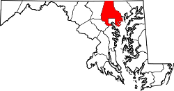
 | |
| Hoamseitn: www.baltimorecountymd.gov | |

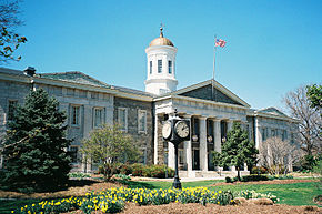
Baltimore County[2] is a County im Bundesstoot Maryland in da USA. Des County hod 805.029 Eihwohna. Da Sitz vo da Vawoitung is in Towson.
Geografie
[Werkeln | Am Gwëntext werkeln]Des County werd im Nordn duach de Mason-Dixon-Linie vo Pennsylvania trennt. Es umfosst nohezu voiständig des ned zum County ghearande Stodgebiet vo Baltimore. Östli davo eareicht des County de Chesapeake Bay. Des Baltimore County hod a Flächn vo 1766 Quadratkilometa, davo san 216 Quadratkilometa Wossaflächn.
Es grenzt an foignde Countys:
| York County (Pennsylvania) |
||
| Carroll County | 
|
Harford County |
| Howard County | Baltimore City, Anne Arundel County |
Gmoana
[Werkeln | Am Gwëntext werkeln]- Arbutus
- Bowleys Quarters
- Carney
- Catonsville
- Cockeysville
- Dundalk
- Edgemere
- Essex
- Garrison
- Hampton
- Kingsville
- Lansdowne-Baltimore Highlands
- Lochearn
- Lutherville-Timonium
- Mays Chapel
- Middle River
- Milford Mill
- Overlea
- Owings Mills
- Parkville
- Perry Hall
- Pikesville
- Randallstown
- Reisterstown
- Rosedale
- Rossville
- Towson
- White Marsh
- Woodlawn
Beleg
[Werkeln | Am Gwëntext werkeln]- ↑ Auszug aus dem National Register of Historic Places - Nr. 72000569 Obgruafa am 30. Juni 2011
- ↑ GNIS-ID: 1695314. Abgerufen am 22. Februar 2011 (englisch).
Im Netz
[Werkeln | Am Gwëntext werkeln]|
Countys in Maryland
|
