Datei:NASA Earth America 2002.jpg
Seiteninhalte werden in anderen Sprachen nicht unterstützt.
Aus Wikipedia

Version in hechara Auflesung(2.048 × 2.048 Pixel, Dateigress: 588 KB, MIME-Typ: image/jpeg)

De Datei kimpt vo Wikimedia Commons. De Beschreibung vo da Dateibschreibungsseitn wead untn ozoagt.

Bschreiwung

Bschreiwung
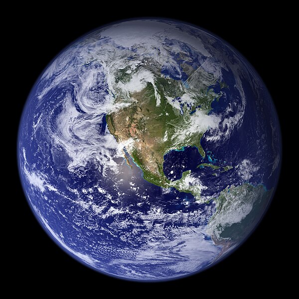
English: This spectacular “blue marble” image is the most detailed true-color image of the entire Earth to date. Using a collection of satellite-based observations, scientists and visualizers stitched together months of observations of the land surface, oceans, sea ice, and clouds into a seamless, true-color mosaic of every square kilometer (.386 square mile) of our planet. These images are freely available to educators, scientists, museums, and the public. This record includes preview images and links to full resolution versions up to 21,600 pixels across.


Much of the information contained in this image came from a single remote-sensing device-NASA’s Moderate Resolution Imaging Spectroradiometer, or MODIS. Flying over 700 km above the Earth onboard the Terra satellite, MODIS provides an integrated tool for observing a variety of terrestrial, oceanic, and atmospheric features of the Earth. The land and coastal ocean portions of these images are based on surface observations collected from June through September 2001 and combined, or composited, every eight days to compensate for clouds that might block the sensor’s view of the surface on any single day. Two different types of ocean data were used in these images: shallow water true color data, and global ocean color (or chlorophyll) data. Topographic shading is based on the GTOPO 30 elevation dataset compiled by the U.S. Geological Survey’s EROS Data Center. MODIS observations of polar sea ice were combined with observations of Antarctica made by the National Oceanic and Atmospheric Administration’s AVHRR sensor—the Advanced Very High Resolution Radiometer. The cloud image is a composite of two days of imagery collected in visible light wavelengths and a third day of thermal infra-red imagery over the poles. Global city lights, derived from 9 months of observations from the Defense Meteorological Satellite Program, are superimposed on a darkened land surface map.
Daatum
Quejn https://www.flickr.com/photos/gsfc/4386822005/in/photostream/
Urhéwer NASA Goddard Space Flight Center Image by Reto Stöckl

Lizenz

Public domain De Datai is gmoafrai (public domain), wais vo da NASA erstöid worn is. In da NASA-Urheewerrechtsrichtlinie steet, dass as „NASA-Materiaal ned durch Urheewerrecht gschytzt is, wånns ned ånders ågeem is“. (NASA-Urheewerrechtsrichtlinie-Saiten oder JPL Image Use Policy).
Warnung:
  • De Vawendung vo NASA-Logos, Woppm und Symboie is durchs US-Gsetz 14 CFR 1221 aigschränkt.
  • D' NASA-Homepage hostet an hauffm Büider vo da Sowjetischen bzw. Russischen Raumfortsagentur sowia ånderne ned-amerikanischer Raumfortagenturn. De Büider san ned gmoafrai.
  • Materiaal vom Hubble-Wöidraumteleskop kå urheewerrechtlich gschytzt sai, wånns ned ausdrycklich vom STScI is. [1]
  • Jeeglichs Materiaal vom Solar and Heliospheric Observatory (SOHO) is urheewerrechtlich gschytzt und ma braucht a gsonderde Geneemigung fyr kommerziöie, ned-pädagogische Zwecke. [2]
  • Büider, de ois Astronomii-Büid vom Tog (APOD) vaeffmtlicht wern, san unter Umständ urheewerrechtlich gschytzt. [3]

Kurzbeschreibungen

Ergänze eine einzeilige Erklärung, was diese Datei darstellt.
A picture of the Earth

In dieser Datei abgebildete Objekte

Motiv Deutsch

Dateiversiona

Wensd auf an Zeitpunkt klickst, nacha konst a friaane Version lodn.

Version vomVorschaubuidlDimensiónaNutzerKommentar
aktuell16:46, 26. Sep. 2014Vuaschaubuid fiad Version vom 16:46, 26. Sep. 2014, 16:46 Uhr2.048 × 2.048 (588 KB)Orange-kunLarger file from the same source
09:55, 6. Mer. 2010Vuaschaubuid fiad Version vom 09:55, 6. Mer. 2010, 09:55 Uhr1.024 × 1.024 (497 KB)CrazyInSane{{Information |Description={{en|1=A depiction of Earth from February 2002, view of America. Released in 2010 by NASA.}} |Source=http://www.flickr.com/photos/gsfc/4386822005/in/photostream/ |Author=NASA Goddard Space Flight Center Image by Reto Stöckl |Da

Seitn wo de Datei nutzn:

Globale Dateinutzung

D'noochéfóiganden åndern Wikis vawénden dé Datei:

Metadaten