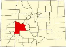
Gunnison County, Colorado
| Vawoitung | |
|---|---|
| US-Bundesstoot: | Colorado |
| Sitz vo da Vawoitung: | Gunnison |
| Grindung: | 1877 |
| Buidt aus: | Lake County |
| Demographie | |
| Eihwohna: | 15.324 (2010) |
| Dichtn: | 1,8 Eihwohna/km² |
| Eadkund | |
| Flächn gesamt: | 8.443 km² |
| Wossaflächn: | 54 km² |
| Koartn | |
 | |
| Hoamseitn: www.gunnisoncounty.org/ | |
Gunnison County[1] is a Beziak im Bundesstoot Colorado in da USA. Da Beziak hod 15.324 Einwohna. Da Sitz vo da Vawoitung is Gunnison.
Da Beziak hod a Fläche vo 8.443 Quadratkilometa, dovo san 54 Quadratkilometa Wossafläche.
Gmoana
[Werkeln | Am Gwëntext werkeln]- Abbeyville
- Almont
- Baldwin
- Chance
- Crested Butte
- Crystal
- Doyleville
- Elkton
- Floresta
- Gateview
- Gothic
- Gunnison
- Irwin
- Marble
- Mount Crested Butte
- Ohio
- Parlin
- Pieplant Mill
- Pitkin
- Pittsburg
- Powderhorn
- Ruby
- Sapinero
- Sillsville
- Somerset
- Tincup
- Waunita Hot Springs
- Whitepine
Beleg
[Werkeln | Am Gwëntext werkeln]- ↑ GNIS-ID: 198141. Abgerufen am 22. Februar 2011 (englisch).
|
Countys in Colorado
|
Koordinaten: 38° 40′ N, 107° 1′ W
