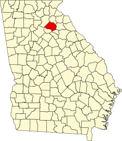
Jackson County, Georgia
Erscheinungsbild
(Weidagloadt vo Jackson County (Georgia))

| Vawoitung | |
|---|---|
| US-Bundesstoot: | Georgia |
| Sitz vo da Vawoitung: | Jefferson |
| Adress vom Vawoitungssitz: |
Jackson County Administration 67 Athens Street Jefferson, Georgia 30549-1401 |
| Grindung: | 1796 |
| Buidt aus: | Franklin County |
| Vuawoi: | 001 706 |
| Demographie | |
| Eihwohna: | 60.485 (2010) |
| Dichtn: | 68,3 Eihwohna/km² |
| Eadkund | |
| Flächn gesamt: | 888 km² |
| Wossaflächn: | 2 km² |
| Koartn | |
 | |
| Hoamseitn: www.jacksoncountygov.com | |
Jackson County[2][3] is a Beziak im Bundesstoot Georgia in da USA. Da Beziak hod 60.485 Eihwohna. Da Sitz vo da Vawoitung is Jefferson.
Da Beziak hod a Fläche vo 888 Quadratkilometa, dovo san 2 Quadratkilometa Wossafläche.
Gmoana
[Werkeln | Am Gwëntext werkeln]- Apple Valley
- Attica
- Brockton
- Center
- Clarksboro
- Constantine
- Dry Pond
- Ednaville
- Fairview
- Grove Level
- Holders
- Holly Springs
- Red Stone
- Sells
- Stoneham
- Thompsons Mills
- Thurmack
- Thyatira
- Wilsons Church
Beleg
[Werkeln | Am Gwëntext werkeln]- ↑ Auszug aus dem National Register of Historic Places. Obgruafa am 13. Meaz 2011
- ↑ GNIS-ID: 349570. Abgerufen am 22. Februar 2011 (englisch).
- ↑ Jackson County bei georgia.gov (Memento des Originals [1] vom 31. Mai 2016 im Internet Archive)
 Info: Der Archivlink wurde automatisch eingesetzt und noch nicht geprüft. Bitte prüfe Original- und Archivlink gemäß Anleitung und entferne dann diesen Hinweis.. Obgruafa am 14. Feba 2011
Beziake (Countys) im Bundesstoot Georgia
Koordinaten: 34° 8′ N, 83° 34′ W
