Malmesbury (Sidafrika)
| Malmesbury | ||
|---|---|---|
|
| ||
| Koordinaten | 33° 27′ 47″ S, 18° 43′ 49″ O | |
| Datei:Koartn | ||
| Basisdatn | ||
| Stoot | [[|Südafrika]] | |
| Westkap | ||
| Distrikt | West Coast | |
| ISO 3166-2 | ZA-WC | |
| Gmoa | Swartland | |
| Häh | 128 m | |
| Flächn | 13,1 km² | |
| Eihwohna | 10.299 (2011) | |
| Dichtn | 789,2 Ew./km² | |
| Gründung | 1743 | |
| Omeakung | ||
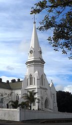
 De holländisch-reformiade Kiach
| ||
Malmesbury is a Stod in da sidafrikanischn Provinz Westkap. Se is Vawoitungssiez vo da Local Municipality Swartland im Distrikt West Coast.
Geografie
[Werkeln | Am Gwëntext werkeln]Im Joar 2011 hom in Malmesbury 10.299 Eihwohna glebd;[1] zamm mi de unmiddlboa bnochboadn Siedlunga, insbsondare: Ilinge Lethu und Wesbank, hod's 35.897 Eihwohna.[2] Malmesbury is Haptort vo da Region Swartland und liegd uma 70 Kilometa neadli vo Kapstadt.[3]
Gschicht
[Werkeln | Am Gwëntext werkeln]1703 san easchte Farmen om heiting Ort im Toi van Diep River eihgrichdd worn; 1743 is da Ort grindd worn.[3] De fimfte holländisch-reformiade Gmoa in da Geschicht vo Sidafrika is in Malmesbury entstondn.[4] Da domoiige Ort Zwartlands Kerk is 1829 z Eahn vo James Harris’, 1. Earl of Malmesbury in Malmesbury umbnennd worn. Da Grof woa da Schwiegavoda van domoiing Gouverneur vo da Kapkolonie, Sir Lowry Coles. 1860 hod Malmesbury Gmoastatus eahoidn.[3]
Om 29. Septemba 1972 hod se ba Malmesbury a schwaara Eisnbohunfoi eaeingd, ois a Peasonazug mid nein Wong entgleisd is. Uma 100 Menschn san gstorm.[5]
Wiatschoft und Vakeah
[Werkeln | Am Gwëntext werkeln]Malmesbury is agrarisch pregd, vo oim duach Droadobau, Weinbau[4] sowia Schof- und Gfliaglzucht. De National Route 7 fiahd in Noad-Sid-Richtung unmiddlboa on Malmesbury voabei und vabinddd Moorreesburg im Noadn mid Kapstadt im Sidn, die R45 fiahd noadwestweats Richtung Saldanha und sidostweats noch Paarl, weahnd de R46 noch Ceres im Ostn fiahd. De R315 schliassli vabindd Malmesbury mi de westli glengne Orte im Gstodbereich, etwa Darling.
Malmesbury hod on Kopfbohhof on da Bohstreckn (Kapstadt–)Kraaifontein–Bitterfontein, de im Guitavakeah bediand wead.
In da Stod stähd's Gfengnis Malmesbury Correctional Centre.
Sunstigs
[Werkeln | Am Gwëntext werkeln]De Malmesbury-Gruppe is de ejdasde Gstoafoamazion van Gebiet. Se stommd aus dem spadn Prekambrium und bstähd aus Grauwacke und Schiefa.[6]
Im Netz
[Werkeln | Am Gwëntext werkeln]- Touristische Hinweise bei sa-venues.com (englisch)
Beleg
[Werkeln | Am Gwëntext werkeln]- ↑ Voikszehjung 2011, obgruafa om 17. August 2015
- ↑ Mount Royal Golf & Country Estate, Wesbank, Malmesbury und Ilinge Lethu (addiad), obgruafa om 17. August 2015
- ↑ 3,0 3,1 3,2 Bschreibung vo da Local Municipality ba localgovernment.co.za (englisch), obgruafa om 17. August 2015
- ↑ 4,0 4,1 Portret ba sa-venues.com (englisch), obgruafa om 17. August 2015
- ↑ Peter W. B. Semmens: Katastrophen auf Schienen. Eine weltweite Dokumentation. Transpress, Stuttgart 1996, ISBN 3-344-71030-3, S. 178.
- ↑ Geologie vo Kapstadt af da Website vo da University of Cape Town (Memento des Originals [1] vom 14. Septémber 2018 im Internet Archive)
 Info: Der Archivlink wurde automatisch eingesetzt und noch nicht geprüft. Bitte prüfe Original- und Archivlink gemäß Anleitung und entferne dann diesen Hinweis. (englisch), obgruafa om 17. August 2015

