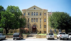
Palo Pinto County, Texas
Erscheinungsbild

| Vawoitung | |
|---|---|
| US-Bundesstoot: | Texas |
| Sitz vo da Vawoitung: | Palo Pinto |
| Adress vom Vawoitungssitz: |
Palo Pinto County Courthouse P.O. Box 219 Palo Pinto, TX 76484-0008 |
| Grindung: | 1856 |
| Buidt aus: | Bosque County Navarro County |
| Vuawoi: | 001 940 |
| Demographie | |
| Eihwohna: | 28.111 (2010) |
| Dichtn: | 11,4 Eihwohna/km² |
| Eadkund | |
| Flächn gesamt: | 2.552 km² |
| Wossaflächn: | 84 km² |
| Koartn | |
 | |
| Hoamseitn: www.co.palo-pinto.tx.us | |
Palo Pinto County[2] is a County im Bundesstoot Texas vo da USA. Da Sitz vo da County-Vawoitung (County Seat) is z Palo Pinto.[3]
Geografie
[Werkeln | Am Gwëntext werkeln]Des County liegt uma 100 km nordöstli vom geografischn Zentrum vo Texas und hod a Flächn vo 2552 Quadratkilometa, wovo 84 Quadratkilometa Wossaflächn san.
Es grenzt im Uahrzoagasinn an foignde Countys:
Jack County, Parker County, Hood County, Erath County, Stephens County und Young County.
Gmoana
[Werkeln | Am Gwëntext werkeln]Beleg
[Werkeln | Am Gwëntext werkeln]- ↑ Auszug aus dem National Register of Historic Places. Obgruafa am 13. Meaz 2011
- ↑ Palo Pinto County im Geographic Names Information System vom United States Geological Survey. Obgruafa am 22. Feba 2011
- ↑ Angaben bei National Association of Counties (Memento des Originals [1] vom 6. Aprü 2012 im Internet Archive)
 Info: Der Archivlink wurde automatisch eingesetzt und noch nicht geprüft. Bitte prüfe Original- und Archivlink gemäß Anleitung und entferne dann diesen Hinweis.. Obgruafa am 10. Oktoba 2012
Im Netz
[Werkeln | Am Gwëntext werkeln]Countys im Bundesstoot Texas
Koordinaten: 32° 45′ N, 98° 19′ W
