South Glengarry
Erscheinungsbild
| South Glengarry | ||
|---|---|---|
 As Doaf Lancaster | ||
| Log in Ontario | ||
| Stoot: | Kanada | |
| Provinz: | Ontario | |
| County: | Stormont, Dundas and Glengarry | |
| Koordinaten: | 45° 12′ N, 74° 35′ W | |
| Fläche: | 605 km² | |
| Eiwohna: | 13.162 (Stand: 2011) | |
| Beväikarungsdichtn: | 21,8 Einw./km² | |
| Zeitzone: | Eastern Time (UTC−5) | |
| Gmoanumma: | {{{Gemeindenummer}}} | |
| Postleitzoi: | K0C | |
| Buagamoasta: | Ian McLeod | |
| Hoamseitn: | www.southglengarry.com | |
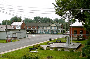
South Glengarry is a Township im County Stormont, Dundas and Glengarry. Es is de estlichsde Gm oa van County und grenzd im Ostn und Sidn on Québec, im Westn grenzds on de Stod Cornwall.
Gliedarung
[Werkeln | Am Gwëntext werkeln]South Glengarry buidd keoa zammhängnds Siedlungsgebiet. Es hondld se um an Administrativn Zammschluss zoihreicha Deafa. Gressde Siedlun is Lancaster.
Vakeah
[Werkeln | Am Gwëntext werkeln]South Glengarry wead duachn Ontario Highway 401, oane vo de bedeitndsdn Autobohna v Kanadas, easchlossn. Driwa naus vafuigds iwa zwoa Flugplätz,: Cornwall Regional Airport (IATA-Flughofncode YCC) und Lancaster Airpark.

