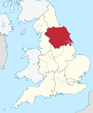
Yorkshire and the Humber
| Yorkshire and the Humber | |
|---|---|
 | |
| Geografie | |
| Fläche | 15.420 km² |
| Verwaltungssitz | Leeds |
| Demografie | |
| Bevejkarung Bevejkarungsdichte |
5.316.691 (Stond: 2012)[1] 345 Eihwohna/km² |
Yorkshire and The Humber is oane vo de nein Region vo England. Iah Gebiet eastreckd se af'n gressdn Tei vo da tradizionejn Grofschoft Yorkshire, aussadem af'n neadlichn Tei vo Lincolnshire, dea za da friahan Grofschoft Humberside ghead hod.
De Region is in de foingndn Grofschoftn, Unitary Authorities und Metropolitan Districts untateid:
|
De Region hod uaspringli: Yorkshire and Humberside ghoassn und hod aus de Grofschoftn: North Yorkshire, West Yorkshire, South Yorkshire und Humberside bstondn. Nochdem Humberside teid, de Grofschoftn West und South Yorkshire obgschoffd und York aus North Yorkshire rausglesd worn is, is de heitige Vawoitungsgliedarung enstondn. De oide Bezeichnung wad aa heit no glengdli bnutzd.
Schau aa
[Werkeln | Am Gwëntext werkeln]Wiatschoft
[Werkeln | Am Gwëntext werkeln]Im Vagleich mid'm BIP vo da EU ausdruckd in Kaffkroftstandard eareichd de Region on Index vo 102.8 (EU-25:100) (2003).[2]
Im Netz
[Werkeln | Am Gwëntext werkeln]- Government Office for Yorkshire and the Humber (Memento vom 22. Juli 2010 im Internet Archive)
Beleg
[Werkeln | Am Gwëntext werkeln]- ↑ Bevejkarung vo England und Wales om 30. Juni 2012 (ZIP; 832 kB)
- ↑ Eurostat News Release 63/2006: Regional GDP per inhabitant in the EU 25 (Memento vom 12. Mäerz 2007 im Internet Archive)
Koordinaten: 53° 34′ N, 1° 12′ W

