Bakerinsl
| Bakerinsl | |
|---|---|
 | |
| Gwassa | Pazifischa Ozean |
| Geographische Log | 0° 11′ 42″ N, 176° 28′ 42″ W |
 | |
| Leng | 2 km |
| Broadn | 1 km |
| Flechn | 1,64 km² |
| Hechsta Beag | 8 m |
| Eiwohna | (unbewohnt) |
| Haptort | Meyerton (historisch) |
 | |
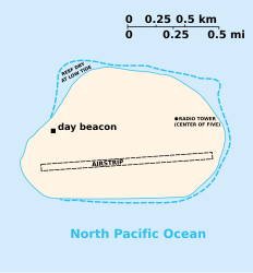
De Bakerinsl (engl. Baker Island), is a kloane, unbewohnte Insl im Pazifik, de wo zu de Aussngebiet vo da USA gheat. Es is a sognennts ned inkorporiats Territorium. De Insl is aa zamm mit da Howlandinsel de oanzige Londfläch mit da Zeitzone UTC-12 (International Date Line West, IDLW).
Eadkunde
[Werkeln | Am Gwëntext werkeln]Den Insl liegt 3.100 Kilometa sidwestli vo Honolulu, ebba auf hoim Wegb zwischn Hawaii und Australien, nua 21,7 Kilometa neadli vom Äquatoa. De Howlandinsel is 68,3 Kilometa entfeant. De Bakerinsl hod a Fläch vo 1,64 km² und an Umfong vo 4,9 km. Sie is a ghobans Atoll und is vo am Korallnriff umgem. Auf da Insl gibts koa Siasswossaquejn.
Gschicht
[Werkeln | Am Gwëntext werkeln]
De Insl is 1818 entdeckt und 1857 vo da USA in Besitz gnomma woan.
Vo 1935 bis 1942 woa de Insl kuanzzeitig bewohnt.
Seit 1974 is de Bakerinsl unta Natuaschutz gstejt. Seitdem deaf de Insl nua mit ana Sondagenehmigung betretn wean.
Literatua
[Werkeln | Am Gwëntext werkeln]- Bryan, Edwin Horace: American Polynesia: coral islands of the Central Pacific; Honolulu, Hawaii 1941
- Maude, Henry Evans: Of islands and men: studies in Pacific history; Melbourne [u. a.] : Oxford Univ. Pr., 1968
Im Netz
[Werkeln | Am Gwëntext werkeln]- CIA World Factbook: Bakerinsel (englisch)
- Jane's Oceania Page - Baker Island (englisch)
- Offizielle Seite des Baker Island National Wildlife Refuge (englisch)
- Weitere Karten der Bakerinsel in der Perry-Castañeda Library Map Collection (englisch)
|
Bundesstootn: Alabama | Alaska | Arizona | Arkansas | Colorado | Connecticut | Delaware | Florida | Georgia | Hawaii | Idaho | Illinois | Indiana | Iowa | Kalifornien | Kansas | Kentucky | Louisiana | Maine | Maryland | Massachusetts | Michigan | Minnesota | Mississippi | Missouri | Montana | Nebraska | Nevada | New Hampshire | New Jersey | New Mexico | New York | Noad-Carolina | Noad-Dakota | Ohio | Oklahoma | Oregon | Pennsylvania | Rhode Island | Sid-Carolina | Siid-Dakota | Tennessee | Texas | Utah | Vermont | Virginia | Washington | West Virginia | Wisconsin | Wyoming Bundesdistrikt: Washington, D.C. Außengebiete: Amerikanisch-Samoa | Jungferninseln | Bakerinsel | Guam | Howlandinsel | Jarvisinsel | Johnstoninsel | Kingmanriff | Midwayinseln | Navassa | Nördliche Marianen | Palmyra | Puerto Rico | Wake |
