
Bedfordshire
| Bedfordshire | |
|---|---|
 | |
| Geografie | |
| Status | Zeremonieje Grofschoft |
| Region | East of England |
| Fläch | 1235 km² |
| ISO 3166-2 | GB-BDF |
| Demografie | |
| Bevejkarung Dichte |
625.019 (Stond: 2012)[1] 506/km² |
| Unitary Authoritys | |
 | |
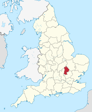
Bedfordshire is a Grofschoft in England. Bedfordshire grenzd on de Grofschoftn: Cambridgeshire, Northamptonshire, Buckinghamshire (mid Milton Keynes) und Hertfordshire.
Luton woa bis 1997 Tei vo da Grofschoft, donn is's zum Stodkroas (Unitary Authority) worn. Om 1. Aprui 2009 is im Zug vo ana Vawoitungsrefoam dea bis domois in Bedford osässige Grofschoftsrod vo Bedfordshire afgläsd worn. Seitdem existiad Bedfordshire ledigli no ois zeremonieje Grofschoft mid de administrativ sejbststending Unitary Authoritys: Luton, Central Bedfordshire und Bedford. De ehemoiing Districts: Mid Bedfordshire und South Bedfordshire san za neien UA Central Bedfordshire vaoanigd und Bedford vo om District zu ana UA eahom worn.
Städt und Ortschoftn
[Werkeln | Am Gwëntext werkeln]Städt mid meah ois 5000 Eihwohna:
Kloanare Ortschoftn:
Sengswiadigkeitn
[Werkeln | Am Gwëntext werkeln]- Chicksands
- Dunstable Downs
- Elstow Moot Hall
- Leighton Buzzard Light Railway
- Luton Hoo
- Stevington Windmill
- Stewartby Lake
- Whipsnade Wildlife Park
- Abtei Woburn
- Woburn Wildlife Park