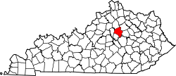
Fayette County, Kentucky
Erscheinungsbild
(Weidagloadt vo Fayette County (Kentucky))

| Vawoitung | |
|---|---|
| US-Bundesstoot: | Kentucky |
| Sitz vo da Vawoitung: | Lexington |
| Adress vom Vawoitungssitz: |
County Courthouse 200 East Main Street Lexington, KY 40507-1310 |
| Grindung: | 1780 |
| Buidt aus: | Original-County |
| Vuawoi: | 001 859 |
| Demographie | |
| Eihwohna: | 295.803 (2010) |
| Dichtn: | 401,9 Eihwohna/km² |
| Eadkund | |
| Flächn gesamt: | 739 km² |
| Wossaflächn: | 3 km² |
| Koartn | |
 | |
| Hoamseitn: www.lfucg.com | |

Fayette County[1] is a Beziak im Bundesstoot Kentucky in da USA. Da Beziak hod 295.803 Eihwohna. Da Sitz vo da Vawoitung is Lexington.
Da Beziak hod a Fläche vo 739 Quadratkilometa, davo san 3 Quadratkilometa Wossafläche.
Gmoana
[Werkeln | Am Gwëntext werkeln]- Ashland Park
- Athens
- Avon
- Baralto
- Beaumont Park
- Blueberry Hill
- Bracktown
- Brigadoon
- Brighton
- Brookhaven
- Cadentown
- Cardinal Hill
- Cardinal Valley
- Centerville
- Chevy Chase
- Chilesburg
- Coletown
- Colony
- Columbus
- Crestwood
- Deep Springs
- Deerfield
- Dixie Plantation
- Donerail
- East Hickman
- Eastland
- Eastland Park
- Elk Chester
- Fairway
- Fenwick
- Fort Spring
- Frogtown
- Gamesway
- Garden Springs
- Gardenside
- Greendale
- Hermitage Hills
- Hi-Acres
- Highlands
- Hinda Heights
- Holiday Hills
- Hollywood
- Idle Hour
- Indian Hills
- Jimtown
- Jonestown
- Kenawood
- Kingston
- Lakeview Acres
- Lansdowne
- Lexington
- Lexington Manor
- Lexington-Fayette
- Liberty Heights
- Little Georgetown
- Little Texas
- Loradale
- Mattoxtown
- Meadowthorpe
- Montclair
- Monticello
- Montrose
- Mount Vernon
- Muir
- Nihizertown
- Open Gates
- Pine Meadows
- Pinehurst
- Pricetown
- Rockwood
- Sandersville
- Shadeland
- Shawneetown
- South Elkhorn
- Southeastern Hills
- Southland
- Spears
- Spindletop Estates
- Stonewall Estates
- Stoneybrook
- Thoroughbred Acres
- Twin Oaks
- Uttingertown
- Viley
- Walnut Hill
- Warrenton
- Westmoreland
- Yarnallton
- Zandale
Beleg
[Werkeln | Am Gwëntext werkeln]- ↑ GNIS-ID: 516880. Abgerufen am 22. Februar 2011 (englisch).
Beziak (Countys) im Bundesstoot Kentucky
Koordinaten: 38° 2′ N, 84° 28′ W
