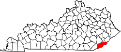
Harlan County, Kentucky
Erscheinungsbild
(Weidagloadt vo Harlan County (Kentucky))

| Vawoitung | |
|---|---|
| US-Bundesstoot: | Kentucky |
| Sitz vo da Vawoitung: | Harlan |
| Adress vom Vawoitungssitz: |
County Courthouse P.O. Box 670 Harlan, KY 40831-0670 |
| Grindung: | 1819 |
| Buidt aus: | Floyd County Knox County |
| Vuawoi: | 001 606 |
| Demographie | |
| Eihwohna: | 29.278 (2010) |
| Dichtn: | 24,2 Eihwohna/km² |
| Eadkund | |
| Flächn gesamt: | 1.212 km² |
| Wossaflächn: | 2 km² |
| Koartn | |
 | |
Harlan County[1] is a Beziak im Bundesstoot Kentucky in da USA. Da Beziak hod 29.278 Eihwohna. Da Sitz vo da Vawoitung is Harlan.
Da Beziak hod a Fläche vo 1212 Quadratkilometa, dovo san 2 Quadratkilometa Wossafläche.
Gmoana
[Werkeln | Am Gwëntext werkeln]- Ages
- Alva
- Bailey Creek
- Bardo
- Baxter
- Benham
- Benito
- Big Laurel
- Black Bottom
- Black Mountain
- Blackjoe
- Blair
- Bledsoe
- Bobs Creek
- Brookside
- Cawood
- Chad
- Chevrolet
- Closplint
- Clover
- Clover-Darby
- Clovertown
- Clutts
- Coldiron
- Colts
- Coxton
- Cranks
- Crummies
- Cumberland
- Darkmont
- Dillon
- Dione
- Divide
- Dizney
- Dressen
- Elcomb
- Evarts
- Farmers Mill
- Fresh Meadows
- Gano
- Gatun
- Georgetown
- Golden Ash
- Harlan
- Harlan Gas
- Highsplint
- Hiram
- Holmes Mill
- Keith
- Kentenia
- Kenvir
- Kildav
- Kitts
- Laden
- Layman
- Lenarue
- Liggett
- Longton
- Louellen
- Loyall
- Lynch
- Martins Fork
- Mary Alice
- Mary Helen
- Molus
- Nolansburg
- Pathfork
- Pine Mountain
- Putney
- Redbud
- Rex
- Rhea
- Ridgeway
- Rileyville
- Rio Vista
- River Ridge
- Rosspoint
- Rutherford
- Sampson
- Sand Hill
- Short Town
- Smith
- South Wallins
- Stanfill
- Sunshine
- Tacky Town
- Teetersville
- Ten Spot
- Three Point
- Totz
- Tremont
- Tway
- Twila
- Verda
- Wallins Creek
- Woods
- Yancey
Beleg
[Werkeln | Am Gwëntext werkeln]- ↑ GNIS-ID: 516894. Abgerufen am 22. Februar 2011 (englisch).
Beziak (Countys) im Bundesstoot Kentucky
Koordinaten: 36° 52′ N, 83° 13′ W
