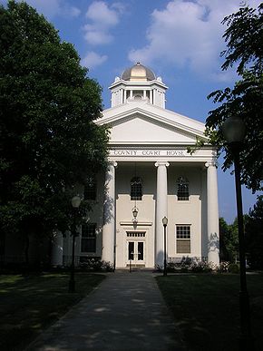
Kenton County, Kentucky
Erscheinungsbild

| Vawoitung | |
|---|---|
| US-Bundesstoot: | Kentucky |
| Sitz vo da Vawoitung: | Covington und Independence |
| Adress vom Vawoitungssitz: |
County Courthouse 303 Court Street Covington, KY 41011-1639 |
| Grindung: | 1840 |
| Buidt aus: | Campbell County |
| Vuawoi: | 001 859 |
| Demographie | |
| Eihwohna: | 159.720 (2010) |
| Dichtn: | 380,3 Eihwohna/km² |
| Eadkund | |
| Flächn gesamt: | 426 km² |
| Wossaflächn: | 6 km² |
| Koartn | |
 | |
| Hoamseitn: www.kentoncounty.org | |
Kenton County[1] is a Beziak im Bundesstoot Kentucky in da USA. Da Beziak hod 159.720 Eihwohna. Da Sitz vo da Vawoitung is Covington und Independence.
Da Beziak hod a Fläche vo 426 Quadratkilometa, dovo san 6 Quadratkilometa Wossafläche.
Gmoana
[Werkeln | Am Gwëntext werkeln]- Alexander
- Atwood
- Bank Lick
- Bracht
- Bromley
- Covington
- Crescent Park
- Crescent Springs
- Crestview Hills
- DeCoursey
- Edgewood
- Elsmere
- Erlanger
- Fairview
- Fiskburg
- Forest Hills
- Fort Mitchell
- Fort Wright
- Grant
- Independence
- Kenton
- Kenton Hills
- Kenton Vale
- Lakeside Park
- Lakeview
- Lamb
- Latonia
- Latonia Lakes
- Lookout Heights
- Ludlow
- Maurice
- Morning View
- Nicholson
- Oak Ridge
- Park Hills
- Piner
- Ricedale
- Ryland
- Ryland Heights
- Sanfordtown
- South Fort Mitchell
- Springdale
- Springlake
- Staffordsburg
- Summit Hills Heights
- Sunny Acres
- Taylor Mill
- Villa Hills
- Visalia
- West Covington
- White Tower
- White Villa
- Winston Park
Beleg
[Werkeln | Am Gwëntext werkeln]- ↑ GNIS-ID: 516905. Abgerufen am 22. Februar 2011 (englisch).
Beziak (Countys) im Bundesstoot Kentucky
Koordinaten: 38° 56′ N, 84° 32′ W
