New York City
| New York City Stod New York | |
|---|---|
| Siegl | Flaggn |
 |
 |
| Basisdatn | |
| Gründung: | 1614 (Quelle #67) |
| Staat: | USA |
| Bundesstoot: | New York |
| Countys: | Bronx (Bronx) New York (Manhattan) Queens (Queens) Kings (Brooklyn) Richmond (Staten Island) |
| Geografische Log: | Koordinaten: 40° 42' N, 74° 00' W 40° 42' N, 74° 00' W |
| Zeitzona | Eastern Standard Time (UTC-5) |
 Log vo da Stadt im Bundesstaat New York |
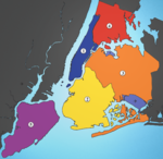
 Die 5 boroughs vo New York: ● (1) Manhattan, ● (2) Brooklyn, ● (3) Queens, ● (4) The Bronx, ● (5) Staten Island |
| Eihwohna: - Metropolregion: |
8,336,697 (2012)[1] 19.750.000 (1.Juli 2007)[2] |
| Spitznama: | The Big Apple |
| Bevejkarungsdichtn: - Metropolregion: |
10.482 Einwohna je km² 824 Einwohna je km² |
| Häh: | 6 m ü. NN |
| Fläch: | 1.214,4 km² davon 785,6 km² Land |
| Stodgliederung: | 5 Stodbeziak |
| Postleitzoin: | 10001-10292 |
| Vorwoi: | 212 |
| Hoamseitn: | www.nyc.gov |
| Politik | |
| Buagamoasta: | Bill de Blasio (Demokrat) |
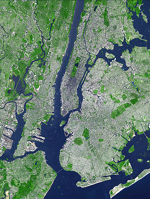
| Satellitnbuidl | |
 | |
De New York City oda Stod New York is mit mehr wia ocht Milliona Einwohna de bevejkarungsreichste Stod vo de USA, de Vaoanigtn Stootn. Ums vom gleichnaming Bundsstoot New York z unterschein, zu dem wo s gheat, werds em Stod New York (Stod Nei York) oda New York City (Obkiazung NYC) gnennt.
Ihr Gbiet umfasst de fimf Boroughs gnennte Stodbeziak Manhattan, Bronx, Brooklyn, Queens und Staten Island. De han in weitane Stodtein gliedat. De Metropolregion New York mit 18,7 Milliona Einwohna[2] is ana vo de bedeitendstn Wirtschaftsraim und Handlsplätz vo da Wejd, Sitz vo vui intanationale Konzerne und Organisationa (so a vo da UNO) und wichtiga Hafn an da Ostküstn vo da USA. D'Stod gniasst mit ihra großn Ozoi voi Sengswiadigkeitn, de 500 Galerien, etwa 200 Museen, mehr als 150 Theatan und mehr als 18.000 Restaurants Wejdruaf in de Bereiche Kunst und Kultur.
Da Spitznom vo New York City is Big Apple.
- 67 = Vertrau
Eadkunde
[Werkeln | Am Gwëntext werkeln]Geografische Log
[Werkeln | Am Gwëntext werkeln]New York City liegt im Noadostn vo da USA, im Siidostn vom Stoot New York, ebba aufm hoim Weg zwischn Washington und Boston.[3] De Log on da Mündung vom Hudson River, on am Natuahofn am Atlantik, hod dazua beitrong, dass de Stod a wichtigs Hondlszentrum woan is.
As Stodzentrum bfindt si af da Insl Manhattan, de ois spitze Fejszunga zwischn Hudson und East River liegt. Vo de Flussufan greift'd Bebaung vo da Stadt mit ana Fülln vo Vorstädt af anderne Großstädt iba un is weit ins Land eine ganga. Sie schließt de Gmoana Bronx, Brooklyn, Queens, Staten Island (ursprüngli: Richmond) und Manhattan zua Stadt New York zam. As Stadtgebiet hat a Landflächn vo 785,6 Quadratkilometa (zum Vagleich: Berlin 891,85 Quadratkilometa). D'New York Metropolitan Area hod a Ausdehnung vo 27.084 Quadratkilometa, des is a bissl klerna als'd Bodenflächn vom Bundesland Brandenburg.
Geologie
[Werkeln | Am Gwëntext werkeln]As Gbiet umd Stod New York is a Tei vo da atlantischen Ufaebane. Weida ins Land eine vawandelt si d Landschaft oimählich in sanfte Hiagl. Af Long Island und entlang vo de Ufagegend vo New Jersey na Sidn befinden si Sandstränd.
De Ufaebane, in dea wo New York liagt, reicht ois Voaland vo de sidlichn Appalachn bis Jacksonville. Sie bsteht aus Sand und Ton. Langzonge Nehrungan und Hogn sand de seichtn, reichgliedatn Ästuarn (Delaware Bay) und de Flussmindunga voaglogat; im Hintaland foigt a broada Gezeitnmarschgiatl. Ebba af da geographischn Broadn vo New York, in Long Island, tauchdt Ufaebane untan Meerespiagl ab.
Stodgliedarung
[Werkeln | Am Gwëntext werkeln]De Stod is in fimf Stodtei (Boroughs) gliedat, von dene jede an Kroas (County) vum Staat New York entspricht. Jeds Borough untastäht an Borough President.
De Stodtei san Manhattan (New York County), Brooklyn (Kings County), Queens (Queens County), Bronx (Bronx County) und Staten Island (Richmond County).
Manhattan (New York County) hod 1.564.798 Einwohna (Stand 1. Juli 2003) und a Landflächn vo 59,5 km². Dea Stodtei bstäht vor oim aus da Insl Manhattan Island, de wo vum Hudson River im Westn, vum East River im Ostn und vum Harlem River im Noadosten umflossn wead und aus weidan kloan Insln, darunta Roosevelt Island, Belmont Island, Governor's Island und an kloan Stickl vum Festland, Marble Hill. Marble Hill wor bis zum Bau vum Harlem River Ship Canal im 19. Joarhundat no Tei vo Manhattan Island.
Gschicht
[Werkeln | Am Gwëntext werkeln]
Zua Zeit wo de easchtn Eiropäa in de Gegnd vom heitign New York keman san, woa des Gebiet vo de Lenape-Indiana bewohnt.[4]
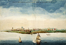
Wia Hollända ogfongt hom mit de Indiana an Fejhondl afziang, is om Sidzipfe vo Manhattan 1614 a easchte Siedlung entstondn, de wos "Nieuw Amsterdam" (Nei-Amsterdam) gnennt hom. 1626 hom de Hollända de gonze Insl Manhatten fia nua 60 Gulden vo de Lenape kafft.
Anno 1664 is de Stod vo de Englända eaobat woan. De hom de Stod auf "New York" umtaft, nochm Duke of York.[5]
Im 18. Joahundat woa New York aktiv on da Unabhängigkeitsbewegung beteiligt. 1776 woas fia kuaza Zeit sogoa s Hauptquartier vom George Washington, is aba nacha vo de Britn besetzt woan.
Vo 1788 bis 1790 woa New York de Haptstod vo da USA. Da George Washington is do aa ois easchta President vaeidigt woan. Nochn Unobhängigkeitskriag is am 17. Mai 1792 de New Yorker Beasn, de New York Stock Exchange, grindt woan.
Am 11. Septemba 2001 is des World Trade Center (WTC) duach an Terroroschlog (9/11) zasteat woan. Es hod bis Mai 2002 dauat, bis de Auframorbatn am Ground Zero (Bezeichnung fias Gelände, wos WTC gstondn is) fiati woan. Aufn Ground Zero wead a Gedenkstättn (is zum Tei scho fiati) baut und s One World Trade Center (fiatigsteït 2014). Mit 541 m is des 1WTC etz des hexte Gebaide vo New York.
Panoramen
[Werkeln | Am Gwëntext werkeln]

Beleg
[Werkeln | Am Gwëntext werkeln]- ↑ U.S. Census Bureau, „Residential Population and Components of Change New York State and Counties, April 1, 2000 to July 1, 2005“
- ↑ 2,0 2,1 U.S. Census Bureau, „Annual Estimates of the Population of Metropolitan and Micropolitan Statistical Areas: April 1, 2000 to July 1, 2004“
- ↑ Washington, DC is 228 miles (367 km) driving distance from New York, and Boston is 217 miles (349 km) driving distance from New York. – Google Maps
- ↑ "Gotham Center for New York City History" Timeline 1500–1700
- ↑ Homberger, Eric: The Historical Atlas of New York City: A Visual Celebration of 400 Year's of New York City's History. Owl Books 2005, ISBN 0805078428
Literatua
[Werkeln | Am Gwëntext werkeln]- Ric Burns, James Sanders, Lisa Ades: New York – Die illustrierte Geschichte von 1609 bis heute, Frederking & Thaler, 2002, ISBN 3-89405-612-6
- Geo Special: New York, Mairdumont, 2003, ISBN 3-570-19399-3
- Horst Hamann, Volker Skierka: New York Vertical 2005
- Sylke Nissen: Die regierbare Stadt. Metropolenpolitik als Konstruktion lösbarer Probleme. New York, London und Berlin im Vergleich, VS Verlag für Sozialwissenschaften, 2002, ISBN 3-531-13844-8
- Russell Shorto: New York – Insel in der Mitte der Welt. Wie die Stadt der Städte entstand. Hamburg 2004 (Rowohlt), ISBN 3-498-06360-X
- Jennifer Toth, Margaret Morton (Illustrator): Tunnel-Menschen. Das Leben unter New York City., Links Verlag, Berlin, 1994, ISBN 3-86153-079-1
- Kathrin Wildner: New York City: Kulturelle Identitäten in einer westlichen Metropole, LIT Verlag Dr. Wilhelm Hopf, 1994, ISBN 3-89473-861-8
- Heike Werner: New York City für Architekten, Minga, 2004, ISBN 3-9809471-0-6
- Kenneth T. Jackson, David S. Dunbar (Hg.): Empire City: New York Through the Centuries. Columbia University Press, New York 2005. ISBN 0-231-10908-3
- Robert A. M. Stern, Thomas Mellins, David Fishman: New York 1960: Architecture and Urbanism between the Second World War and the Bicentennial. New York: Monacelli, 1999. ISBN 1-885254-85-7
- Kenneth T. Jackson (Hg.): The Encyclopedia of New York City. New Haven: Yale University Press 1995. ISBN 0-300-05536-6
- Norval White: New York: A Physical History. New York: Atheneum, 1988. ISBN 0-689-11658-6
- John A. Kouwenhoven: The Columbia Historical Portrait of New York. Garden City: Doubleday & Company 1953.
