Washington County, Kentucky
Erscheinungsbild
| Vawoitung | |
|---|---|
| US-Bundesstoot: | Kentucky |
| Sitz vo da Vawoitung: | Springfield |
| Adress vom Vawoitungssitz: |
County Courthouse P.O. Box 126 Springfield, KY 40069-0126 |
| Grindung: | 22. Juni 1792 |
| Buidt aus: | Nelson County |
| Vuawoi: | 001 859 |
| Demographie | |
| Eihwohna: | 11.717 (2010) |
| Dichtn: | 15 Eihwohna/km² |
| Eadkund | |
| Flächn gesamt: | 781 km² |
| Wossaflächn: | 2 km² |
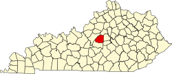
| Koartn | |
 | |


Washington County[1] is a Beziak im Bundesstoot Kentucky in da USA. Da Beziak hod 11.717 Eihwohna. Da Sitz vo da Vawoitung is Nelson County.
Da Beziak hod a Fläche vo 781 Quadratkilometa, davo san 2 Quadratkilometa Wossafläche.
Gmoana
[Werkeln | Am Gwëntext werkeln]- Battle
- Bearwallow
- Booker
- Briartown
- Brush Grove
- Cardwell
- Cisselville
- Croakes
- Deep Creek
- Fairview
- Fredericktown
- Hardesty
- Jenkinsville
- Jimtown
- Litsey
- Mackville
- Manton
- Maud
- Mooresville
- Pleasant Grove
- Polin
- Pottsville
- Pulliam
- Rineltown
- Seaville
- Sharpsville
- Simstown
- Springfield
- Tablow
- Tatham Springs
- Texas
- Thompsonville
- Valley Hill
- Willisburg
Beleg
[Werkeln | Am Gwëntext werkeln]- ↑ GNIS-ID: 516961. Abgerufen am 22. Februar 2011 (englisch).
Beziak (Countys) im Bundesstoot Kentucky
Koordinaten: 37° 45′ N, 85° 10′ W
